1980s Maps of Chalfant Valley, California
Explore 2 historic maps of Chalfant Valley from the 1980s. These maps offer a rare glimpse into what life looked like during the 1980s — showing old roads, neighborhoods, homes, and landmarks that have changed or disappeared over time.
Whether you're researching your family's past, planning a metal detecting trip, or studying how Chalfant Valley's landscape evolved across the 1980s, these high-resolution maps are a powerful tool for exploring the history of this region.
- Focus on a specific era: All maps on this page are from the 1980s, giving you a focused view of this time period.
- See what’s changed: Compare century-old streets, trails, and buildings to today's modern landscape using overlays and satellite layers.
- Research with precision: Use these maps for genealogy, historical research, land use analysis, or educational projects.
- View, download, or print: Maps are fully viewable online in high resolution, and can be downloaded or printed for your own records.
Start exploring Chalfant Valley's history through authentic maps from the 1980s. This is your window into the past.
Chalfant Valley, CA maps
(2)- 1987 Map of Chalfant Valley
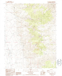 1987 Chalfant Valley1987 Print · USGSChalfant Valley and the high desert of the White Mountains are captured here in the late eighties, showing a landscape of mining and water infrastructure. Researchers can trace the paths of the Aqueduct and locate historic workings like the Jeffrey Mine and Sacramento Mine.
 - 1988 Map of Benton Range
 1988 Benton Range1988 Print · USGSThe high desert and alpine peaks of the California-Nevada border come alive in this late-century survey of the Benton Range. Researchers can trace the heritage of remote outposts like Benton and Montgomery City alongside historic workings like the Black Warrior Mine.2 unique versions available
End of results
Showing maps 1-2 of 2
Top cities near Chalfant Valley
- Bishop historical maps
- Dixon Lane–Meadow Creek historical maps
- West Bishop historical maps
- Round Valley historical maps
- Mesa historical maps
Frequently asked questions
- What are the different types of historical maps available for Chalfant Valley?
- What is the oldest map of Chalfant Valley?
- Where can I purchase historical maps of Chalfant Valley for my home or office?
- Where can I download high-res historical maps of Chalfant Valley?
- Are there historical topographic maps available for Chalfant Valley?
- Is there historical aerial imagery available for Chalfant Valley?
- Where are historical maps of Chalfant Valley sourced from?