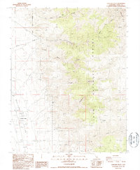
1987 Map of Chalfant Valley
USGS Topo · Published 1987About this map
The Chalfant Valley settlement occupies a narrow corridor of development between the towering White Mts and the desert floor in the late 1980s. This landscape is defined by its industrial and hydraulic infrastructure, featuring an extensive Aqueduct and a Powerhouse that reflect the region's historical role in water and power management. Evidence of mineral exploration is scattered across the alluvial fans and canyon mouths, with numerous sites such as the Jeffrey Mine, the Copper Queen Mine, and the Sacramento Mine marking the rugged slopes. Within the Inyo National Forest, the terrain is deeply incised by drainages like Jeffrey Canyon and Sabies Canyon, while high-altitude features like Moulés Mine suggest the difficult reach of early 20th-century prospecting. The presence of a Radio Facility and multiple Prospect sites indicates a mix of modern communication needs and enduring geological interest in the high desert.
Find a feature on this map
23 named features on this map. Tap any name to fly to it.
Don’t see what you’re looking for? This feature index may not catch every label — zoom into the map to look around manually.
Map Details
Editions of this 1987 Chalfant Valley Map
This is the sole edition of this map. No revisions or reprints were ever made.
Other maps of this area

1913 · Bishop
USGS Topo · 1:125,000

1917 · White Mountain
USGS Topo · 1:125,000

1947 · Mariposa
USGS Topo · 1:250,000

1948 · Mariposa
USGS Topo · 1:250,000

1949 · Bishop
USGS Topo · 1:62,500

1951 · Bishop
USGS Topo · 1:62,500

1951 · Blanco Mountain
USGS Topo · 1:62,500

1957 · Mariposa
USGS Topo · 1:250,000

1962 · Mt. Barcroft
USGS Topo · 1:62,500

1962 · White Mtn. Peak
USGS Topo · 1:62,500