
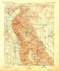
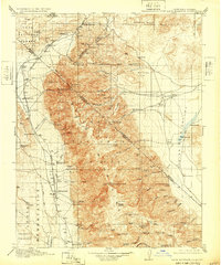
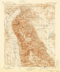
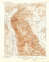
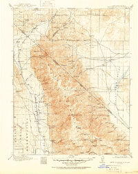
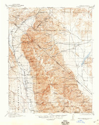
1917 Map of White Mountain
USGS Topo · Published 1917About this map
White Mountain Peak dominates this high-altitude landscape along the border of California and Nevada, presiding over the rugged White Mountains and the sprawling Inyo National Forest. This 1913-1914 survey reveals an economy rooted in high-desert ranching and hard-rock mining, with the Southern Pacific railroad line skirting the western edge through the Volcanic Tableland. In the eastern lowlands of Fish Lake Valley, a network of remote homesteads such as Chiatovich Ranch and the McNett Ranch rely on seasonal runoff from Indian Creek and McAfee Creek. The map documents a scattered human presence at the height of the mining era, from the Mocalno PO at Cinnamon Ranch to specialized operations like the Black Warrior Mine and Queen Mines. A distinct northern boundary is marked by the Mt Diablo Base Line, while the Inyo Indian Reservation occupies the southwestern corner of the sheet.
Find a feature on this map
93 named features on this map. Tap any name to fly to it.
Don’t see what you’re looking for? This feature index may not catch every label — zoom into the map to look around manually.
Map Details
Editions of this 1917 White Mountain Map
7 editions found
Other maps of this area

1898 · Silver Peak
USGS Topo · 1:125,000

1900 · Silver Peak
USGS Topo · 1:125,000

1907 · Tonopah
USGS Topo · 1:250,000

1908 · Lida
USGS Topo · 1:250,000

1908 · Tonopah
USGS Topo · 1:250,000

1909 · Hawthorne
USGS Topo · 1:250,000

1911 · Hawthorne
USGS Topo · 1:250,000

1912 · Mt. Goddard
USGS Topo · 1:125,000

1913 · Bishop
USGS Topo · 1:125,000

1913 · Lida
USGS Topo · 1:250,000