1980s Maps of Oasis, California
Explore 2 historic maps of Oasis from the 1980s. These maps offer a rare glimpse into what life looked like during the 1980s — showing old roads, neighborhoods, homes, and landmarks that have changed or disappeared over time.
Whether you're researching your family's past, planning a metal detecting trip, or studying how Oasis's landscape evolved across the 1980s, these high-resolution maps are a powerful tool for exploring the history of this region.
- Focus on a specific era: All maps on this page are from the 1980s, giving you a focused view of this time period.
- See what’s changed: Compare century-old streets, trails, and buildings to today's modern landscape using overlays and satellite layers.
- Research with precision: Use these maps for genealogy, historical research, land use analysis, or educational projects.
- View, download, or print: Maps are fully viewable online in high resolution, and can be downloaded or printed for your own records.
Start exploring Oasis's history through authentic maps from the 1980s. This is your window into the past.
Oasis, CA maps
(2)- 1985 Map of Last Chance Range
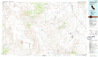 1985 Last Chance Range1985 Print · USGSThe high deserts of the California-Nevada border come alive in the mid-eighties, showing a landscape shaped by remote mining and volcanic geology. Researchers can trace historic extraction routes at the Sylvania Mine, locate the iconic Scotty's Castle, or follow the Old Railroad Grade past Bonnie Claire.2 unique versions available
 - 1988 Map of Chocolate Mtn
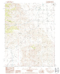 1988 Chocolate Mtn1988 Print · USGSThe high-desert borderlands of Mono and Inyo counties are captured here in the late eighties, showing a landscape defined by mining and isolation. Trace the remains of White Mountain City, the Copper Queen Mine, and the remote settlement of Oasis.2 unique versions available
End of results
Showing maps 1-2 of 2
Top cities near Oasis
Frequently asked questions
- What are the different types of historical maps available for Oasis?
- What is the oldest map of Oasis?
- Where can I purchase historical maps of Oasis for my home or office?
- Where can I download high-res historical maps of Oasis?
- Are there historical topographic maps available for Oasis?
- Is there historical aerial imagery available for Oasis?
- Where are historical maps of Oasis sourced from?