1940s Maps of King City, California
Explore 4 historic maps of King City from the 1940s. These maps offer a rare glimpse into what life looked like during the 1940s — showing old roads, neighborhoods, homes, and landmarks that have changed or disappeared over time.
Whether you're researching your family's past, planning a metal detecting trip, or studying how King City's landscape evolved across the 1940s, these high-resolution maps are a powerful tool for exploring the history of this region.
- Focus on a specific era: All maps on this page are from the 1940s, giving you a focused view of this time period.
- See what’s changed: Compare century-old streets, trails, and buildings to today's modern landscape using overlays and satellite layers.
- Research with precision: Use these maps for genealogy, historical research, land use analysis, or educational projects.
- View, download, or print: Maps are fully viewable online in high resolution, and can be downloaded or printed for your own records.
Start exploring King City's history through authentic maps from the 1940s. This is your window into the past.
King City, CA maps
(4)- 1948 Map of Santa Cruz
 1948 Santa Cruz1948 Print · USGSThe Central Coast and San Joaquin Valley meet in this mid-century look at the region's agricultural and military geography. Genealogists and historians can trace the paths of El Camino Real, locate family farms near Hollister, or study the footprint of the Fort Ord Military Reservation.2 unique versions available
 - 1948 Map of King City, 1955 Print
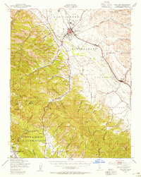 1948 King City1955 Print · USGSThe Salinas River valley and the rugged southern Coast Ranges are captured here in the late 1940s during a period of significant military and agricultural activity. Genealogists and historians can trace old homesteads near Argyle, the historic San Antonio Mission, and the early layout of King City.2 unique versions available
 - 1949 Map of San Lucas
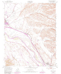 1949 San Lucas1949 Print · USGSThe Salinas Valley thrives as a rail and ranching hub in the late 1940s, anchored by the growth of the Southern Pacific line. Researchers can trace the layout of King City, locate the Mesa Del Rey Airport, and find smaller stops like Welby and San Lucas.5 unique versions available
 - 1949 Map of Thompson Canyon, 1952 Print
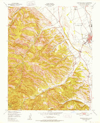 1949 Thompson Canyon1952 Print · USGSThe Salinas Valley transitions from fertile river plains to deep canyons in this late 1940s survey. Researchers can trace the mid-century growth of King City along the Southern Pacific line and locate the Cem and Ruins near the canyon floors.4 unique versions available
End of results
Showing maps 1-4 of 4
Top cities near King City
Frequently asked questions
- What are the different types of historical maps available for King City?
- What is the oldest map of King City?
- Where can I purchase historical maps of King City for my home or office?
- Where can I download high-res historical maps of King City?
- Are there historical topographic maps available for King City?
- Is there historical aerial imagery available for King City?
- Where are historical maps of King City sourced from?