1940s Maps of Penvir, California
Explore 3 historic maps of Penvir from the 1940s. These maps offer a rare glimpse into what life looked like during the 1940s — showing old roads, neighborhoods, homes, and landmarks that have changed or disappeared over time.
Whether you're researching your family's past, planning a metal detecting trip, or studying how Penvir's landscape evolved across the 1940s, these high-resolution maps are a powerful tool for exploring the history of this region.
- Focus on a specific era: All maps on this page are from the 1940s, giving you a focused view of this time period.
- See what’s changed: Compare century-old streets, trails, and buildings to today's modern landscape using overlays and satellite layers.
- Research with precision: Use these maps for genealogy, historical research, land use analysis, or educational projects.
- View, download, or print: Maps are fully viewable online in high resolution, and can be downloaded or printed for your own records.
Start exploring Penvir's history through authentic maps from the 1940s. This is your window into the past.
Penvir, CA maps
(3)- 1940 Map of Gonzales, 1947 Print
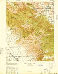 1940 Gonzales1947 Print · USGSMonterey and San Benito counties meet in the high Gabilan Range during the pre-war era of ranching and early highway travel. Genealogy researchers can find the Paicines Ranch, tracing old schoolhouses like Paicines School and the rails of the Southern Pacific.
 - 1941 Map of Gonzales
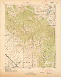 1941 Gonzales1941 Print · USGSThe Salinas Valley meets the Gabilan Range in this early 1940s tactical survey of Monterey and San Benito Counties. Genealogists can locate rural landmarks like Paicines Ranch, Willow Grove School, and the Southern Pacific stop at Dean.
 - 1948 Map of Santa Cruz
 1948 Santa Cruz1948 Print · USGSThe Central Coast and San Joaquin Valley meet in this mid-century look at the region's agricultural and military geography. Genealogists and historians can trace the paths of El Camino Real, locate family farms near Hollister, or study the footprint of the Fort Ord Military Reservation.2 unique versions available
End of results
Showing maps 1-3 of 3
Top cities near Penvir
- Salinas historical maps
- Soledad historical maps
- Prunedale historical maps
- Greenfield historical maps
- Gonzales historical maps
Frequently asked questions
- What are the different types of historical maps available for Penvir?
- What is the oldest map of Penvir?
- Where can I purchase historical maps of Penvir for my home or office?
- Where can I download high-res historical maps of Penvir?
- Are there historical topographic maps available for Penvir?
- Is there historical aerial imagery available for Penvir?
- Where are historical maps of Penvir sourced from?