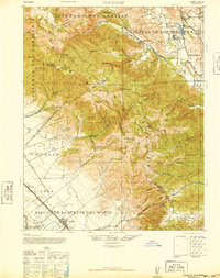
1940 Map of Gonzales
USGS Topo · Published 1947About this map
The Gabilan Range dominates this landscape, serving as the high boundary between the San Benito and Monterey county line. In the Salinas Valley below, the Southern Pacific railroad parallels the main highway through Gonzales, which is surrounded by the expansive lands of Rincon de la Puente del Monte. This area shows a transition from the intensive agricultural activity of the valley floor to the sparse ranching and mining operations of the uplands, such as the Dolomite Quarry near Grass Valley.
Find a feature on this map
55 named features on this map. Tap any name to fly to it.
Don’t see what you’re looking for? This feature index may not catch every label — zoom into the map to look around manually.
Map Details
Editions of this 1940 Gonzales Map
This is the sole edition of this map. No revisions or reprints were ever made.
Other maps of this area

1910 · Gonzales
USGS Topo · 1:31,680

1910 · Salinas
USGS Topo · 1:31,680

1910 · Soledad
USGS Topo · 1:31,680

1912 · Salinas
USGS Topo · 1:62,500

1915 · Soledad
USGS Topo · 1:62,500

1915 · San Juan Bautista
USGS Topo · 1:48,000

1917 · San Juan Bautista
USGS Topo · 1:62,500

1919 · San Benito
USGS Topo · 1:62,500

1919 · Hollister
USGS Topo · 1:48,000

1920 · Jamesburg
USGS Topo · 1:48,000