1940s Maps of Nevada City, California
Explore 4 historic maps of Nevada City from the 1940s. These maps offer a rare glimpse into what life looked like during the 1940s — showing old roads, neighborhoods, homes, and landmarks that have changed or disappeared over time.
Whether you're researching your family's past, planning a metal detecting trip, or studying how Nevada City's landscape evolved across the 1940s, these high-resolution maps are a powerful tool for exploring the history of this region.
- Focus on a specific era: All maps on this page are from the 1940s, giving you a focused view of this time period.
- See what’s changed: Compare century-old streets, trails, and buildings to today's modern landscape using overlays and satellite layers.
- Research with precision: Use these maps for genealogy, historical research, land use analysis, or educational projects.
- View, download, or print: Maps are fully viewable online in high resolution, and can be downloaded or printed for your own records.
Start exploring Nevada City's history through authentic maps from the 1940s. This is your window into the past.
Nevada City, CA maps
(4)- 1948 Map of Nevada City, 1953 Print
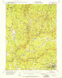 1948 Nevada City1953 Print · USGSNevada City and the Yuba River canyons are captured here in the late 1940s, just as modern reservoirs began to reshape the old gold country. Genealogists and historians can trace family-named sites like Godfrey Ranch (Pike PO), Pleasant Valley Sch, and the Nevada City Rancheria.4 unique versions available
 - 1948 Map of Nevada City, 1957 Print
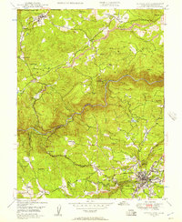 1948 Nevada City1957 Print · USGSThe Gold Country of the Sierra foothills is captured here shortly after the war, showing the historic mining hubs and river crossings of Nevada County. Researchers can locate legacy sites like Cherokee Diggings, the Nevada City Airport, and family holdings like Robinson Ranch.4 unique versions available
 - 1949 Map of Grass Valley, 1953 Print
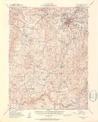 1949 Grass Valley1953 Print · USGSGold mining operations dominate the landscape around the Sierra foothills just after the war. Local researchers can trace the extent of the Empire Mine, find remote outposts like Anthony House, or locate rural schools such as Limekiln Sch and Forest Springs Sch.5 unique versions available
 - 1949 Map of Grass Valley, 1954 Print
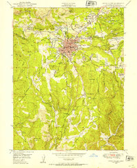 1949 Grass Valley1954 Print · USGSGrass Valley stands at a postwar industrial peak, surrounded by legendary gold mines and expanding mountain neighborhoods. Genealogists and historians can locate family plots at Greenwood Mem Cem and trace old school districts like Forest Springs Sch.3 unique versions available
End of results
Showing maps 1-4 of 4
Top cities near Nevada City
- Grass Valley historical maps
- Colfax historical maps
- Rough and Ready historical maps
- Washington historical maps
Frequently asked questions
- What are the different types of historical maps available for Nevada City?
- What is the oldest map of Nevada City?
- Where can I purchase historical maps of Nevada City for my home or office?
- Where can I download high-res historical maps of Nevada City?
- Are there historical topographic maps available for Nevada City?
- Is there historical aerial imagery available for Nevada City?
- Where are historical maps of Nevada City sourced from?