Old Maps of Rough and Ready, California for Academic Research
Study the evolution of Rough and Ready with 17 high-resolution historic maps. Whether you're teaching, researching, or modeling changes in land use, these maps provide essential visual documentation of urban, environmental, and geographic change.
- Analyze long-term change: Track patterns in development, transportation, and natural features.
- Ideal for environmental or urban studies: Support academic projects with primary historical map data.
- Use in the classroom or lab: Educators and researchers rely on these maps to bring historical context to life.
These maps are a powerful tool for teaching, research, and visualizing how Rough and Ready has changed over the decades.
Rough and Ready, CA maps
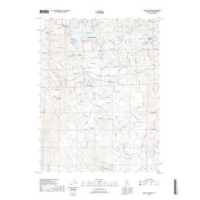
(17)- 1888 Map of Smartsville
 1888 Smartsville1888 Print · USGSGold Country was in its industrial prime during the late eighteen-hundreds, with deep-shaft mines and hydraulic camps dotting the Sierra foothills. Researchers can trace early family holdings and mining claims through landmarks like French Corral, the North Star Mine, and the historic settlement of Timbuctoo.
 - 1891 Map of Smartsville
 1891 Smartsville1891 Print · USGSGold Country in the late nineteenth century was a landscape of deep mines and timber rails. This survey allows researchers to trace the industrial footprint of the Idaho and North Star Mine alongside vanished camps like Condemned Bar and French Corral.
 - 1892 Map of Smartsville
 1892 Smartsville1892 Print · USGSThe gold-bearing ridges of the Sierra foothills are captured here in the late nineteenth century, showing the height of the hard-rock mining boom. Researchers can trace the narrow-gauge rail lines and locate famous claims including the Empire Mine, Idaho Mine, and the Sulphuret Works.
 - 1894 Map of Smartsville
 1894 Smartsville1894 Print · USGSIn the mid-1880s, the Sierra foothills around Nevada City and Grass Valley were a hive of mining and ranching activity. Genealogists and historians can trace old homesteads like Lanes Ranch, follow the Nevada Co Narrow Gauge RR, and locate forgotten camps like Rough & Ready.
 - 1895 Map of Smartsville
 1895 Smartsville1895 Print · USGSThe Northern Mother Lode thrives during the peak of industrial quartz mining in the late nineteenth century. Researchers can trace the complex rail and mine networks of Nevada City and Grass Valley, alongside historic outposts like Smartsville and Rough & Ready.6 unique versions available
 - 1949 Map of Grass Valley, 1953 Print
 1949 Grass Valley1953 Print · USGSGold mining operations dominate the landscape around the Sierra foothills just after the war. Local researchers can trace the extent of the Empire Mine, find remote outposts like Anthony House, or locate rural schools such as Limekiln Sch and Forest Springs Sch.5 unique versions available
 - 1949 Map of Rough And Ready, 1955 Print
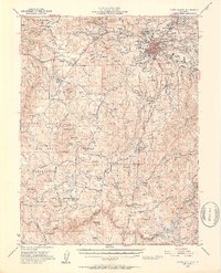
 1949 Rough And Ready1955 Print · USGSThe California Gold Country is captured here at the close of the 1940s, highlighting the transition from mining heritage to ranching and military expansion. Researchers can trace the flumes and ditches of the Rough and Ready district or locate the Clear Creek Sch and Camp Beale Military Reservation.3 unique versions available
 - 1950 Map of Rough And Ready
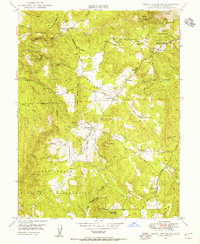
 1950 Rough And Ready1950 Print · USGSGold Country history and post-war military expansion intersect in this Nevada County survey from the late forties. Researchers can trace the water flumes of China Hill, locate the Mistletoe Mine, and find the rural Clear Creek Sch and Anthony House settlement.
 - 1958 Map of Chico, 1962 Print
 1958 Chico1962 Print · USGSMid-century Northern California comes to life across the Central Valley and high Sierras as the postwar economy transformed the landscape. Trace the rail lines of the Southern Pacific RR, locate family roots near Chico Cem, or explore the early layout of Paradise and Beale Air Force Base.4 unique versions available
 - 1960 Map of Chico
 1960 Chico1960 Print · USGSThe Northern California high country and Sacramento Valley meet in this 1960s-era landscape of mining towns and river settlements. Trace the rail-and-water economy of the gold country through the Empire Mine, Beale Air Force Base, and the Western Pacific Railroad.
 - 1993 Map of Yuba City, 1994 Print
 1993 Yuba City1994 Print · USGSThe Sacramento Valley and Sierra Nevada foothills meet in the 1990s, where agricultural bypasses and river networks surround the iconic Sutter Buttes. Researchers can trace the rail corridors of the Southern Pacific and Western Pacific through hubs like Marysville and Gridley.
 - 1995 Map of Rough And Ready
 1995 Rough And Ready1995 Print · USGSThe foothills of the Sierra Nevada are captured in the mid-nineties, showing the growing community of Penn Valley and the waters of Lake Wildwood. Researchers can trace the legacy of local gold mining at the Kentucky Ridge Prospects or locate family roots near Ready Springs Union Sch.
 - 1998 Map of Rough And Ready, 2002 Print
 1998 Rough And Ready2002 Print · USGSThe Gold Country near Nevada County transitions from its mining past into a modern residential landscape in the late nineties. Genealogists and historians can trace family-named landmarks like Haney Mountain, visit the Ready Springs Union Sch, or locate old prospects near Rough and Ready.
 - 2012 Map of Rough And Ready, 2012 Print
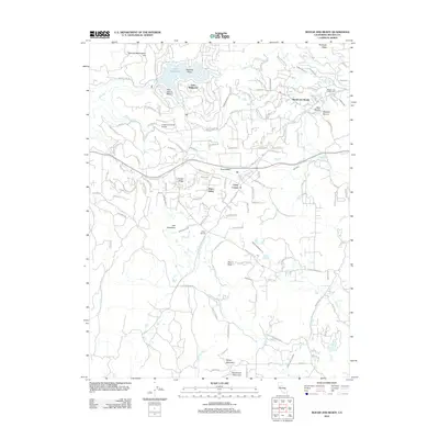 2012 Rough And Ready2012 Print · USGSCovers Rough and Ready, including Casey Corner, Lake Wildwood, and other nearby areas
 - 2015 Map of Rough And Ready, 2015 Print
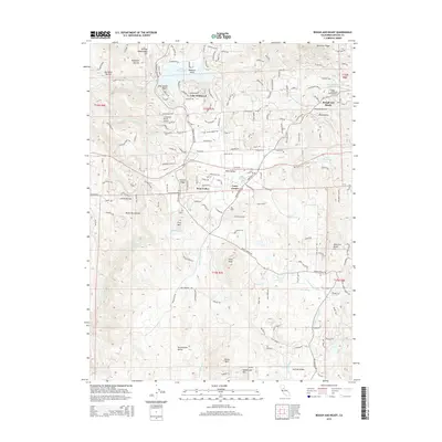 2015 Rough And Ready2015 Print · USGSCovers Rough and Ready, including Casey Corner, Lake Wildwood, and other nearby areas
 - 2018 Map of Rough And Ready, 2018 Print
 2018 Rough And Ready2018 Print · USGSCovers Rough and Ready, including Casey Corner, Lake Wildwood, and other nearby areas
 - 2021 Map of Rough And Ready, 2021 Print
 2021 Rough And Ready2021 Print · USGSNevada County's historic gold country landscape appears here in the early twenty-first century, balancing modern residential growth with its deep mining roots. Researchers can locate several burial grounds including Rough and Ready Cem and trace historic water systems like the Tarr Ditch.
End of results
Showing maps 1-17 of 17
Top cities near Rough and Ready
Frequently asked questions
- What are the different types of historical maps available for Rough and Ready?
- What is the oldest map of Rough and Ready?
- Where can I purchase historical maps of Rough and Ready for my home or office?
- Where can I download high-res historical maps of Rough and Ready?
- Are there historical topographic maps available for Rough and Ready?
- Is there historical aerial imagery available for Rough and Ready?
- Where are historical maps of Rough and Ready sourced from?