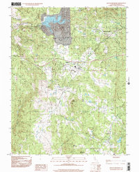
1998 Map of Rough And Ready
USGS Topo · Published 2002About this map
Rough and Ready serves as the focal point of this late 20th-century landscape, positioned near the junction of Penn Valley Road and Ready Road. The map documents a blend of established gold-country legacy and modern water management, centered on the artificial Lake Wildwood and its notable Spillway 1206. The terrain is deeply carved by water systems, including the historical Kentucky Ridge Ditch and Mooney Ditch, which trace the complex topography of Kentucky Ridge and Horton Ridge.
Find a feature on this map
45 named features on this map. Tap any name to fly to it.
Don’t see what you’re looking for? This feature index may not catch every label — zoom into the map to look around manually.
Map Details
Editions of this 1998 Rough And Ready Map
This is the sole edition of this map. No revisions or reprints were ever made.
Other maps of this area

1888 · Smartsville
USGS Topo · 1:125,000

1891 · Smartsville
USGS Topo · 1:125,000

1892 · Smartsville
USGS Topo · 1:125,000

1894 · Smartsville
USGS Topo · 1:125,000

1895 · Smartsville
USGS Topo · 1:125,000

1915 · Spenceville
USGS Topo · 1:31,680

1941 · Bangor
USGS Topo · 1:62,500

1944 · Bangor
USGS Topo · 1:62,500

1948 · Nevada City
USGS Topo · 1:62,500
1948 · Oregon House
USGS Topo · 1:24,000