
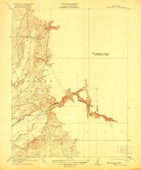
1915 Map of Spenceville
USGS Topo · Published 1915About this map
The Johnson Rancho land grant dominates the western landscape of this preliminary survey, where the low hills meet the winding course of the Bear River. This 1915 edition, based on earlier fieldwork by surveyors like E. R. Bartlett and M. A. Knock, captures a moment when the regional economy was defined by ranching and river access rather than modern infrastructure. A critical transport link is visible at McCourtney Crossing, providing a vital ford across the river at the junction of Yuba and Nevada counties. The map provides remarkable topographic detail along the steep banks of the Bear River and the drainage of Dry Creek, tracing the intricate contours of the foothills before the arrival of significant 20th-century water management projects. Researchers can also identify smaller geographic landmarks like Fenton Ravine in the southeastern corner, illustrating the detailed mapping of the gold country's drainage patterns.
Find a feature on this map
9 named features on this map. Tap any name to fly to it.
Don’t see what you’re looking for? This feature index may not catch every label — zoom into the map to look around manually.
Map Details
Editions of this 1915 Spenceville Map
2 editions found
Other maps of this area

1888 · Smartsville
USGS Topo · 1:125,000

1891 · Sacramento
USGS Topo · 1:125,000

1891 · Smartsville
USGS Topo · 1:125,000

1892 · Sacramento
USGS Topo · 1:125,000

1892 · Smartsville
USGS Topo · 1:125,000

1893 · Sacramento
USGS Topo · 1:125,000

1894 · Smartsville
USGS Topo · 1:125,000

1895 · Smartsville
USGS Topo · 1:125,000

1910 · Sheridan
USGS Topo · 1:31,680

1910 · Lincoln
USGS Topo · 1:31,680