
1915 Map of Spenceville
USGS Topo · Published 1921About this map
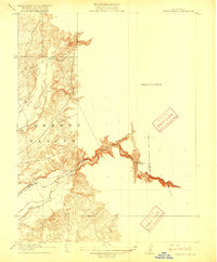
The Johnson Rancho land grant dominates the western landscape of this 1915 survey, reflecting the enduring legacy of California’s Mexican-era land divisions in Yuba County. Much of the eastern portion of the sheet is marked as a Preliminary Edition Unsurveyed Area, creating a stark visual contrast between the measured topography of the rancho and the then-uncharted territory to the east.
Find a feature on this map
9 named features on this map. Tap any name to fly to it.
Don’t see what you’re looking for? This feature index may not catch every label — zoom into the map to look around manually.
Map Details
Editions of this 1915 Spenceville Map
2 editions found
Historical Maps of Waldo Junction Through Time
50 maps found

1911 Browns Valley
Yuba County, CA

1911 Ostrom
Yuba County, CA

1912 Prairie Creek
Yuba County, CA
1915 Spenceville
Yuba County, CA

1947 Browns Valley
Yuba County, CA

1948 Challenge
Yuba County, CA

1948 French Corral
Yuba County, CA

1948 Oregon House
Yuba County, CA

1948 Strawberry Valley
Yuba County, CA

1949 Browns Valley
Yuba County, CA

1949 Camp Far West
Yuba County, CA

1949 Smartville
Yuba County, CA

1950 Challenge
Yuba County, CA

1950 French Corral
Yuba County, CA

1950 Oregon House
Yuba County, CA

1950 Strawberry Valley
Yuba County, CA

1951 Camp Far West
Yuba County, CA

1951 Smartville
Yuba County, CA

1994 Strawberry Valley
Yuba County, CA

1995 Camp Far West
Yuba County, CA

1995 Challenge
Yuba County, CA

1995 French Corral
Yuba County, CA

1995 Oregon House
Yuba County, CA

1995 Smartville
Yuba County, CA

2000 Challenge
Yuba County, CA

2000 French Corral
Yuba County, CA

2012 Browns Valley
Yuba County, CA

2012 Camp Far West
Yuba County, CA

2012 Challenge
Yuba County, CA

2012 French Corral
Yuba County, CA

2012 Oregon House
Yuba County, CA

2012 Strawberry Valley
Yuba County, CA

2015 Browns Valley
Yuba County, CA

2015 Camp Far West
Yuba County, CA

2015 Challenge
Yuba County, CA

2015 French Corral
Yuba County, CA

2015 Oregon House
Yuba County, CA

2015 Strawberry Valley
Yuba County, CA

2018 Browns Valley
Yuba County, CA

2018 Camp Far West
Yuba County, CA

2018 Challenge
Yuba County, CA

2018 French Corral
Yuba County, CA

2018 Oregon House
Yuba County, CA

2018 Strawberry Valley
Yuba County, CA

2021 Browns Valley
Yuba County, CA

2021 Oregon House
Yuba County, CA

2021 Strawberry Valley
Yuba County, CA

2022 Camp Far West
Yuba County, CA

2022 Challenge
Yuba County, CA

2022 French Corral
Yuba County, CA