1900s (20th Century) Maps of Truckee, California
Explore 13 historic maps of Truckee from the 1900s (20th Century). These maps offer a rare glimpse into what life looked like during the 1900s — showing old roads, neighborhoods, homes, and landmarks that have changed or disappeared over time.
Whether you're researching your family's past, planning a metal detecting trip, or studying how Truckee's landscape evolved across the 1900s, these high-resolution maps are a powerful tool for exploring the history of this region.
- Focus on a specific era: All maps on this page are from the 1900s, giving you a focused view of this time period.
- See what’s changed: Compare century-old streets, trails, and buildings to today's modern landscape using overlays and satellite layers.
- Research with precision: Use these maps for genealogy, historical research, land use analysis, or educational projects.
- View, download, or print: Maps are fully viewable online in high resolution, and can be downloaded or printed for your own records.
Start exploring Truckee's history through authentic maps from the 1900s. This is your window into the past.
Truckee, CA maps
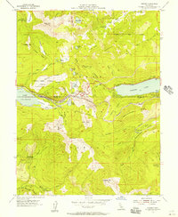
(13)- 1932 Map of Truckee
 1932 Truckee1932 Print · USGSThe high Sierra and Lake Tahoe's western shore are captured here in the early thirties as the region balanced industrial mining and timber with a growing seasonal economy. Trace early lakeside developments from Tahoe Tavern to Meeks Bay PO, or locate historical sites like the Walker Mine and Donner Monument.
 - 1940 Map of Truckee
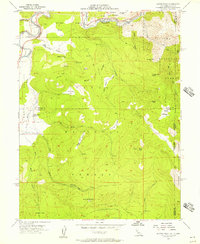
 1940 Truckee1940 Print · USGSThe High Sierra and Lake Tahoe shoreline appear here in the pre-war era, showing a landscape defined by timber, tourism, and transit. Genealogists and historians can trace the early resort development at Tahoe Vista, the lumber works at Hobart Mills, and the vital Southern Pacific rail line.4 unique versions available
 - 1955 Map of Truckee, 1956 Print
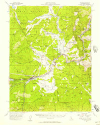
 1955 Truckee1956 Print · USGSIn the mid-1950s, Truckee was a vital rail and transit hub where pioneer history met modern expansion. Genealogists and historians can trace family sites at Joerger Ranch or locate the Murphy Cabin and Graves Cabin near the shore of Donner Lake.5 unique versions available
 - 1955 Map of Donner Pass, 1957 Print
 1955 Donner Pass1957 Print · USGSThe Sierra Nevada crest in the mid-fifties is defined by the critical transit corridor through Donner Pass and the high alpine lakes of the Tahoe region. Local historians can trace the Southern Pacific Railroad as it passes through Soda Springs and Norden or locate the historic Henness Pass Road.4 unique versions available
 - 1955 Map of Truckee, 1957 Print
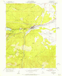
 1955 Truckee1957 Print · USGSThe High Sierra near the Nevada border comes alive in the mid-fifties as a crossroads of rail history and pioneer memory. Researchers can trace the Southern Pacific Railroad through the canyon to Truckee or locate historic spots like the Joerger Ranch and Hobart Mills.4 unique versions available
 - 1955 Map of Boca, 1957 Print
 1955 Boca1957 Print · USGSThe California-Nevada borderlands in the mid-1950s show a landscape defined by the Truckee River and mountain rail transit. Trace the Southern Pacific line through Floriston, find the Boca Dam spillway, or locate the lookout atop Verdi Peak.7 unique versions available
 - 1955 Map of Norden, 1957 Print
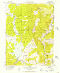
 1955 Norden1957 Print · USGSDonner Pass and the Sierra Nevada crest are captured here in the mid-fifties, during a period of transition for this critical mountain corridor. Genealogists and historians can trace the Southern Pacific rail line through Norden, locate the Old Stanford Wood Camp (Site), or find remote outposts like the Peter Grubb Hut.5 unique versions available
 - 1955 Map of Martis Peak, 1957 Print
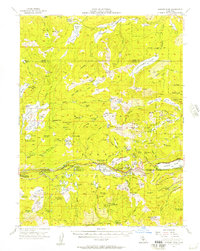
 1955 Martis Peak1957 Print · USGSThe High Sierra at the Nevada-California line appears here in the mid-fifties, dominated by the Southern Pacific rail corridor and high timberlands. Trace the locations of the Old Joerger Ranch, the historic Union Mills (Site), and the fire lookout atop Martis Peak.5 unique versions available
 - 1958 Map of Chico, 1962 Print
 1958 Chico1962 Print · USGSMid-century Northern California comes to life across the Central Valley and high Sierras as the postwar economy transformed the landscape. Trace the rail lines of the Southern Pacific RR, locate family roots near Chico Cem, or explore the early layout of Paradise and Beale Air Force Base.4 unique versions available
 - 1960 Map of Chico
 1960 Chico1960 Print · USGSThe Northern California high country and Sacramento Valley meet in this 1960s-era landscape of mining towns and river settlements. Trace the rail-and-water economy of the gold country through the Empire Mine, Beale Air Force Base, and the Western Pacific Railroad.
 - 1977 Map of Truckee, 1978 Print
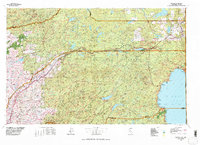 1977 Truckee1978 Print · USGSThe High Sierra and Lake Tahoe regions come into focus in the late seventies, showing a landscape defined by massive reservoir projects and mountain transit. Genealogists and historians can trace the Southern Pacific rail line through Truckee or explore old mining districts near North Bloomfield and Colfax.2 unique versions available
 - 1992 Map of Martis Peak, 1994 Print
 1992 Martis Peak1994 Print · USGSThe Sierra Nevada high country comes into focus in the early nineties as classic timber lands gave way to year-round recreation. Trace the history of the Union Mills (Site), the summit at Martis Peak, and the early layout of Northstar-at-Tahoe.2 unique versions available
 - 1992 Map of Truckee, 1994 Print
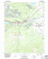 1992 Truckee1994 Print · USGSTruckee and the surrounding Sierra Nevada highlands are shown in the early nineties, centered on the vital rail and river crossing. Historians can trace the Emigrant Road Trail and locate significant sites like the Murphy Cabin (Site) and Joerger Ranch.2 unique versions available
End of results
Showing maps 1-13 of 13
Top cities near Truckee
- Reno historical maps
- Kings Beach historical maps
- Tahoe Vista historical maps
- Cedar Flat historical maps
- Carnelian Bay historical maps
- Crystal Bay historical maps
See more
Top neighborhoods of Truckee
- Tahoe Donner historical maps
- Glenshire-Devonshire historical maps
- Gateway historical maps
- West End Donner historical maps
- Blitz Tract historical maps
- Prosser Lake Heights historical maps
See more
Frequently asked questions
- What are the different types of historical maps available for Truckee?
- What is the oldest map of Truckee?
- Where can I purchase historical maps of Truckee for my home or office?
- Where can I download high-res historical maps of Truckee?
- Are there historical topographic maps available for Truckee?
- Is there historical aerial imagery available for Truckee?
- Where are historical maps of Truckee sourced from?