1950s Maps of Westminster, California
Explore 8 historic maps of Westminster from the 1950s. These maps offer a rare glimpse into what life looked like during the 1950s — showing old roads, neighborhoods, homes, and landmarks that have changed or disappeared over time.
Whether you're researching your family's past, planning a metal detecting trip, or studying how Westminster's landscape evolved across the 1950s, these high-resolution maps are a powerful tool for exploring the history of this region.
- Focus on a specific era: All maps on this page are from the 1950s, giving you a focused view of this time period.
- See what’s changed: Compare century-old streets, trails, and buildings to today's modern landscape using overlays and satellite layers.
- Research with precision: Use these maps for genealogy, historical research, land use analysis, or educational projects.
- View, download, or print: Maps are fully viewable online in high resolution, and can be downloaded or printed for your own records.
Start exploring Westminster's history through authentic maps from the 1950s. This is your window into the past.
Westminster, CA maps
(8)- 1950 Map of Anaheim
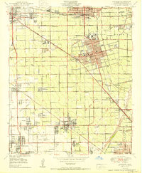 1950 Anaheim1950 Print · USGSPost-war Orange County flourishes here, showing the growth of central citrus hubs before the freeway era. Genealogists can trace family names at Anaheim Cemetery or find historic labor enclaves like Colonia Independencia and Colonia Manzanillo.
 - 1950 Map of Los Alamitos
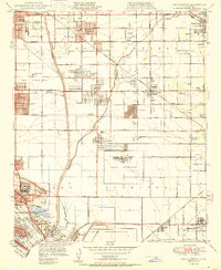 1950 Los Alamitos1950 Print · USGSCoastal Southern California is captured here in the mid-century as citrus groves and ranches gave way to defense facilities and new suburbs. Researchers can trace the development of Hawaiian Gardens or locate family history at Artesia Cem and the Pioneer Sch.
 - 1950 Map of Seal Beach
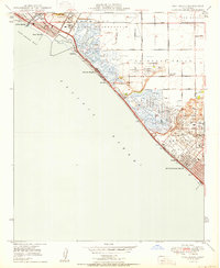 1950 Seal Beach1950 Print · USGSThe Orange County coast in the late Forties is a landscape of expansive wetlands, oil derricks, and emerging beach towns. Researchers can trace the Pacific Electric rail route or locate vanished landmarks like East Long Beach Airport and Wintersburg.
 - 1951 Map of Newport Beach
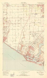 1951 Newport Beach1951 Print · USGSCoastal Orange County in the early fifties reveals a landscape of emerging suburbs and working oil fields before the era of major freeways. Genealogists and local historians can trace the foundations of Costa Mesa and Huntington Beach, or locate vanished landmarks like Balboa Airport and Colonia Juarez.2 unique versions available
 - 1956 Map of Santa Ana
 1956 Santa Ana1956 Print · USGSSouthern California underwent massive mid-century transformation as suburban growth met major military and water projects. Trace the postwar expansion of Santa Ana and Riverside, the layout of Camp Pendleton, and the path of the Colorado River Aqueduct.
 - 1957 Map of Long Beach
 1957 Long Beach1957 Print · USGSThe Los Angeles coast and the Channel Islands appear here during the mid-fifties era of rapid suburbanization and naval expansion. Genealogists and researchers can locate early industrial neighborhoods like South Gate and trace military boundaries at Ft MacArthur Upper Reservation or the remote San Nicolas Island.4 unique versions available
 - 1958 Map of Long Beach
 1958 Long Beach1958 Print · USGSCoastal Southern California is shown during a mid-century period of intense suburbanization and military readiness. Genealogists and historians can trace the growth of Long Beach, identify early neighborhoods in Lakewood Village, or locate the bounds of Ft MacArthur Lower Reservation.
 - 1959 Map of Santa Ana, 1971 Print
 1959 Santa Ana1971 Print · USGSSouthern California is captured in a decade of transformation, from the Orange County coast to the desert floor. Researchers can trace the mid-century footprints of Camp Pendleton, March Air Force Base, and the original Ortega Highway.3 unique versions available
End of results
Showing maps 1-8 of 8
Top cities near Westminster
- Los Angeles historical maps
- Long Beach historical maps
- Anaheim historical maps
- Santa Ana historical maps
- Irvine historical maps
- Huntington Beach historical maps
See more
Top neighborhoods of Westminster
Frequently asked questions
- What are the different types of historical maps available for Westminster?
- What is the oldest map of Westminster?
- Where can I purchase historical maps of Westminster for my home or office?
- Where can I download high-res historical maps of Westminster?
- Are there historical topographic maps available for Westminster?
- Is there historical aerial imagery available for Westminster?
- Where are historical maps of Westminster sourced from?