1930s Maps of Westminster, California
Explore 5 historic maps of Westminster from the 1930s. These maps offer a rare glimpse into what life looked like during the 1930s — showing old roads, neighborhoods, homes, and landmarks that have changed or disappeared over time.
Whether you're researching your family's past, planning a metal detecting trip, or studying how Westminster's landscape evolved across the 1930s, these high-resolution maps are a powerful tool for exploring the history of this region.
- Focus on a specific era: All maps on this page are from the 1930s, giving you a focused view of this time period.
- See what’s changed: Compare century-old streets, trails, and buildings to today's modern landscape using overlays and satellite layers.
- Research with precision: Use these maps for genealogy, historical research, land use analysis, or educational projects.
- View, download, or print: Maps are fully viewable online in high resolution, and can be downloaded or printed for your own records.
Start exploring Westminster's history through authentic maps from the 1930s. This is your window into the past.
Westminster, CA maps
(5)- 1932 Map of Newport Beach
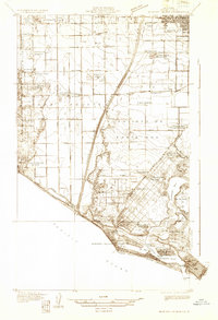 1932 Newport Beach1932 Print · USGSThe Orange County coast was a landscape of agricultural sidings and early seaside resorts in the early thirties. Trace family history through Colonia Juarez, locate the Balboa Ferry, or find old schoolhouses like Greenville Sch.
 - 1935 Map of Los Alamitos
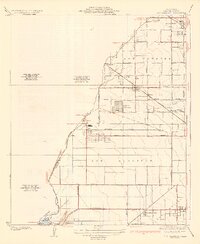 1935 Los Alamitos1935 Print · USGSOrange County's coastal plain is captured in the mid-thirties as rural ranch lands began to yield to industrial expansion. Genealogists and researchers can trace early settlements like Los Alamitos and Buena Park or locate landmarks like the Texas Oil Tank Farm.2 unique versions available
 - 1935 Map of Seal Beach
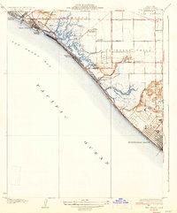 1935 Seal Beach1935 Print · USGSThe Orange County coast in the mid-thirties remains a landscape of sprawling salt marshes and private gun clubs. Trace the early shorefront at Sunset Beach or locate historic markers like Anaheim Landing and the Springdale Sch.3 unique versions available
 - 1935 Map of Garden Grove
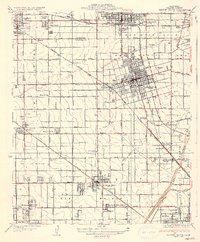 1935 Garden Grove1935 Print · USGSOrange County's citrus heartland is captured here in the mid-1930s, showing a grid of groves and rail lines. Trace family history at Colonia Manzanillo, find the Anaheim Cem, or locate the old Fullerton Landing Field.3 unique versions available
 - 1935 Map of Newport Beach
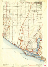 1935 Newport Beach1935 Print · USGSOrange County's coastline and interior plains are captured in the mid-1930s, showing a transition from citrus groves to coastal resorts. Trace the early development of Lido Isle, the sugar beet settlements of Smeltzer, and the tracks of the Pacific Electric.3 unique versions available
End of results
Showing maps 1-5 of 5
Top cities near Westminster
- Los Angeles historical maps
- Long Beach historical maps
- Anaheim historical maps
- Santa Ana historical maps
- Irvine historical maps
- Huntington Beach historical maps
See more
Top neighborhoods of Westminster
Frequently asked questions
- What are the different types of historical maps available for Westminster?
- What is the oldest map of Westminster?
- Where can I purchase historical maps of Westminster for my home or office?
- Where can I download high-res historical maps of Westminster?
- Are there historical topographic maps available for Westminster?
- Is there historical aerial imagery available for Westminster?
- Where are historical maps of Westminster sourced from?