1950s Maps of Gilberts, California
Explore 3 historic maps of Gilberts from the 1950s. These maps offer a rare glimpse into what life looked like during the 1950s — showing old roads, neighborhoods, homes, and landmarks that have changed or disappeared over time.
Whether you're researching your family's past, planning a metal detecting trip, or studying how Gilberts's landscape evolved across the 1950s, these high-resolution maps are a powerful tool for exploring the history of this region.
- Focus on a specific era: All maps on this page are from the 1950s, giving you a focused view of this time period.
- See what’s changed: Compare century-old streets, trails, and buildings to today's modern landscape using overlays and satellite layers.
- Research with precision: Use these maps for genealogy, historical research, land use analysis, or educational projects.
- View, download, or print: Maps are fully viewable online in high resolution, and can be downloaded or printed for your own records.
Start exploring Gilberts's history through authentic maps from the 1950s. This is your window into the past.
Gilberts, CA maps
(3)- 1953 Map of Bunker Hill, 1955 Print
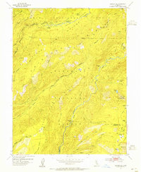 1953 Bunker Hill1955 Print · USGSThe Placer County high country in the early fifties was a realm of remote cow camps and forest guard stations. Genealogists and historians can trace old mountain outposts like Dobbas Cow Camp, the site of the McGuire Mine, and the natural flow of the Middle Fork American River before it was dammed.5 unique versions available
 - 1953 Map of Granite Chief, 1959 Print
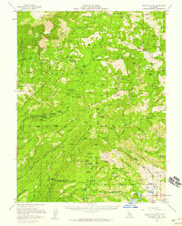 1953 Granite Chief1959 Print · USGSThe High Sierra backcountry of Placer and El Dorado Counties is captured here in the mid-1950s, during a period of transition between early mining and modern forest recreation. Researchers can locate remote sites like the Trinidad Mine, the Watson Monument, and the French Meadows Guard Station.5 unique versions available
 - 1958 Map of Chico, 1962 Print
 1958 Chico1962 Print · USGSMid-century Northern California comes to life across the Central Valley and high Sierras as the postwar economy transformed the landscape. Trace the rail lines of the Southern Pacific RR, locate family roots near Chico Cem, or explore the early layout of Paradise and Beale Air Force Base.4 unique versions available
End of results
Showing maps 1-3 of 3
Frequently asked questions
- What are the different types of historical maps available for Gilberts?
- What is the oldest map of Gilberts?
- Where can I purchase historical maps of Gilberts for my home or office?
- Where can I download high-res historical maps of Gilberts?
- Are there historical topographic maps available for Gilberts?
- Is there historical aerial imagery available for Gilberts?
- Where are historical maps of Gilberts sourced from?