1970s Maps of Corona, California
Explore 4 historic maps of Corona from the 1970s. These maps offer a rare glimpse into what life looked like during the 1970s — showing old roads, neighborhoods, homes, and landmarks that have changed or disappeared over time.
Whether you're researching your family's past, planning a metal detecting trip, or studying how Corona's landscape evolved across the 1970s, these high-resolution maps are a powerful tool for exploring the history of this region.
- Focus on a specific era: All maps on this page are from the 1970s, giving you a focused view of this time period.
- See what’s changed: Compare century-old streets, trails, and buildings to today's modern landscape using overlays and satellite layers.
- Research with precision: Use these maps for genealogy, historical research, land use analysis, or educational projects.
- View, download, or print: Maps are fully viewable online in high resolution, and can be downloaded or printed for your own records.
Start exploring Corona's history through authentic maps from the 1970s. This is your window into the past.
Corona, CA maps
(4)- 1974 Map of Lake Mathews, 1975 Print
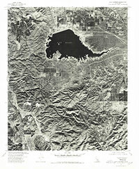 1974 Lake Mathews1975 Print · USGSRiverside County's high ridges and massive reservoir system are captured in this mid-seventies aerial study. Researchers can trace the steep geography of Dawson Canyon and the rugged slopes surrounding Estelle Mtn as they border Lake Mathews.
 - 1974 Map of Corona South, 1975 Print
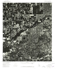
 1974 Corona South1975 Print · USGSRiverside and Orange County landscapes are captured in 1974 through high-resolution aerial imagery during a period of rapid suburban expansion. Researchers can trace the intersection of commercial agriculture and natural terrain through the winding path of Bedford Canyon.
 - 1974 Map of Black Star Canyon, 1977 Print
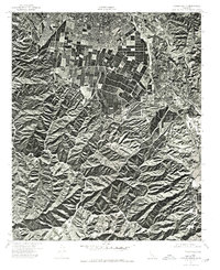
 1974 Black Star Canyon1977 Print · USGSThe Santa Ana Mountains are captured in detail during the mid-seventies, showing this rugged landscape before suburban expansion. Researchers can trace the original shoreline of Santiago Reservoir and the natural path of the Santa Ana River.
 - 1975 Map of Corona North, 1979 Print
 1975 Corona North1979 Print · USGSThe Riverside area comes into sharp focus during the mid-seventies as agricultural fields begin to give way to suburban development. Local historians can trace the intricate landscape of the Prado flood basin and the growing neighborhoods of Riverside during this period of transition.
End of results
Showing maps 1-4 of 4
Top cities near Corona
- Anaheim historical maps
- Riverside historical maps
- Irvine historical maps
- Fontana historical maps
- Ontario historical maps
- Rancho Cucamonga historical maps
See more
Top neighborhoods of Corona
- Dos Lagos historical maps
- Corona Spectrum historical maps
- Pepper Corner historical maps
- Jasmine Springs historical maps
- Las Palmas historical maps
Frequently asked questions
- What are the different types of historical maps available for Corona?
- What is the oldest map of Corona?
- Where can I purchase historical maps of Corona for my home or office?
- Where can I download high-res historical maps of Corona?
- Are there historical topographic maps available for Corona?
- Is there historical aerial imagery available for Corona?
- Where are historical maps of Corona sourced from?