1950s Maps of Hemet, California
Explore 8 historic maps of Hemet from the 1950s. These maps offer a rare glimpse into what life looked like during the 1950s — showing old roads, neighborhoods, homes, and landmarks that have changed or disappeared over time.
Whether you're researching your family's past, planning a metal detecting trip, or studying how Hemet's landscape evolved across the 1950s, these high-resolution maps are a powerful tool for exploring the history of this region.
- Focus on a specific era: All maps on this page are from the 1950s, giving you a focused view of this time period.
- See what’s changed: Compare century-old streets, trails, and buildings to today's modern landscape using overlays and satellite layers.
- Research with precision: Use these maps for genealogy, historical research, land use analysis, or educational projects.
- View, download, or print: Maps are fully viewable online in high resolution, and can be downloaded or printed for your own records.
Start exploring Hemet's history through authentic maps from the 1950s. This is your window into the past.
Hemet, CA maps
(8)- 1953 Map of Winchester, 1954 Print
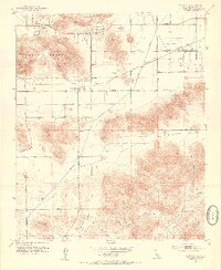 1953 Winchester1954 Print · USGSWinchester and the surrounding San Jacinto Valley are shown in the early 1950s as the regional infrastructure began to modernize. Researchers can trace the path of the Atchison Topeka and Santa Fe railroad or locate landmarks like Ryan Field and the local Cem.7 unique versions available
 - 1953 Map of San Jacinto, 1954 Print
 1953 San Jacinto1954 Print · USGSThe San Jacinto Valley was a vital corridor of water engineering and rail transport in the early fifties. Genealogists and local historians can trace the foundations of San Jacinto and Hemet, along with the Soboba Indian Reservation and Gilman Hot Springs.4 unique versions available
 - 1953 Map of Lakeview, 1955 Print
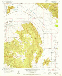 1953 Lakeview1955 Print · USGSThe San Jacinto River valley was a landscape of ranches and massive water works in the early fifties. Genealogists and researchers can trace the Colorado River Aqueduct as it passes near Lakeview, the Bar V Ranch, and Juniper Springs.3 unique versions available
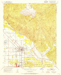
 - 1953 Map of Hemet, 1955 Print
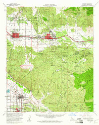
 1953 Hemet1955 Print · USGSThe San Jacinto Valley thrives in the mid-fifties, showing a region defined by its citrus groves and high desert ranching. Genealogists and local historians can trace the early footprints of Hemet and Valle Vista or locate the site of the Mission Ranch at the base of the hills.6 unique versions available
 - 1956 Map of Santa Ana
 1956 Santa Ana1956 Print · USGSSouthern California underwent massive mid-century transformation as suburban growth met major military and water projects. Trace the postwar expansion of Santa Ana and Riverside, the layout of Camp Pendleton, and the path of the Colorado River Aqueduct.
 - 1956 Map of Banning, 1961 Print
 1956 Banning1961 Print · USGSRiverside County towns and mountain passes are captured here during the mid-1950s. Genealogists and historians can trace the development of Banning, San Jacinto, and Beaumont while locating landmarks like St Boniface Sch and Sunnyslope Cem.2 unique versions available
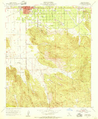
 - 1957 Map of Hemet, 1960 Print
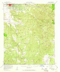 1957 Hemet1960 Print · USGSRiverside County at mid-century reveals a landscape of growing valley towns like Hemet and agricultural ranches bordering the national forest. Researchers can trace rural life through the San Ignacio School, the Williamson Mine, and the Atchison Topeka and Santa Fe rail line.3 unique versions available
 - 1959 Map of Santa Ana, 1971 Print
 1959 Santa Ana1971 Print · USGSSouthern California is captured in a decade of transformation, from the Orange County coast to the desert floor. Researchers can trace the mid-century footprints of Camp Pendleton, March Air Force Base, and the original Ortega Highway.3 unique versions available
End of results
Showing maps 1-8 of 8
Top cities near Hemet
- Moreno Valley historical maps
- Murrieta historical maps
- Temecula historical maps
- Menifee historical maps
- Perris historical maps
- San Jacinto historical maps
See more
Top neighborhoods of Hemet
Frequently asked questions
- What are the different types of historical maps available for Hemet?
- What is the oldest map of Hemet?
- Where can I purchase historical maps of Hemet for my home or office?
- Where can I download high-res historical maps of Hemet?
- Are there historical topographic maps available for Hemet?
- Is there historical aerial imagery available for Hemet?
- Where are historical maps of Hemet sourced from?