1990s Maps of Hemet, California
Explore 2 historic maps of Hemet from the 1990s. These maps offer a rare glimpse into what life looked like during the 1990s — showing old roads, neighborhoods, homes, and landmarks that have changed or disappeared over time.
Whether you're researching your family's past, planning a metal detecting trip, or studying how Hemet's landscape evolved across the 1990s, these high-resolution maps are a powerful tool for exploring the history of this region.
- Focus on a specific era: All maps on this page are from the 1990s, giving you a focused view of this time period.
- See what’s changed: Compare century-old streets, trails, and buildings to today's modern landscape using overlays and satellite layers.
- Research with precision: Use these maps for genealogy, historical research, land use analysis, or educational projects.
- View, download, or print: Maps are fully viewable online in high resolution, and can be downloaded or printed for your own records.
Start exploring Hemet's history through authentic maps from the 1990s. This is your window into the past.
Hemet, CA maps
(2)- 1996 Map of San Jacinto, 1999 Print
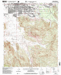
 1996 San Jacinto1999 Print · USGSSan Jacinto and Hemet appear during a period of significant valley growth in the mid-nineties, framed by the towering peaks of the San Jacinto Mountains. Genealogists and local historians can trace the historic San Jacinto Nuevo y Potrero Grant lines alongside the Soboba Indian Reservation and Gilman Hot Springs.
 - 1996 Map of Hemet, 1999 Print
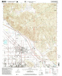
 1996 Hemet1999 Print · USGSHemet and the surrounding San Jacinto Valley are shown in the mid-1990s as suburban growth began to push into the nearby ranch lands. Researchers can trace the development of Hemet, the layouts of Valle Vista, and the footprint of the Searl Ranch.
End of results
Showing maps 1-2 of 2
Top cities near Hemet
- Moreno Valley historical maps
- Murrieta historical maps
- Temecula historical maps
- Menifee historical maps
- Perris historical maps
- San Jacinto historical maps
See more
Top neighborhoods of Hemet
Frequently asked questions
- What are the different types of historical maps available for Hemet?
- What is the oldest map of Hemet?
- Where can I purchase historical maps of Hemet for my home or office?
- Where can I download high-res historical maps of Hemet?
- Are there historical topographic maps available for Hemet?
- Is there historical aerial imagery available for Hemet?
- Where are historical maps of Hemet sourced from?