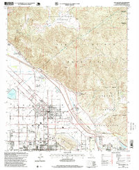
1996 Map of San Jacinto
USGS Topo · Published 1999About this map
The San Jacinto Mountains dominate the eastern landscape of this mid-1990s survey, rising sharply above the valley floor where the San Jacinto River basin meets burgeoning residential grids. The map records a complex overlay of land tenure, from the historic San Jacinto Nuevo y Potrero Grant boundaries to the Soboba Indian Reservation and Morongo Indian Reservation. Urban expansion is evident in the structured street layouts of San Jacinto and Hemet, which are defined by a network of major thoroughfares such as Ramona Expy and Idyllwild Drive. Critical infrastructure is clearly marked, including the Colorado River Aqueduct and San Diego Aqueduct, which trace the periphery of the mountains. Significant local landmarks like Gilman Hot Springs, Soboba Hot Springs, and the San Jacinto Reservoir reflect the region's reliance on water resources and its history as a destination for thermal springs.
Find a feature on this map
41 named features on this map. Tap any name to fly to it.
Don’t see what you’re looking for? This feature index may not catch every label — zoom into the map to look around manually.
Map Details
Editions of this 1996 San Jacinto Map
This is the sole edition of this map. No revisions or reprints were ever made.
Other maps of this area

1901 · Southern California Sheet No. 1
USGS Topo · 1:250,000

1901 · San Jacinto
USGS Topo · 1:125,000

1901 · Elsinore
USGS Topo · 1:125,000

1904 · Southern California Sheet No. 1
USGS Topo · 1:250,000

1942 · Banning
USGS Topo · 1:62,500

1942 · Hemet
USGS Topo · 1:62,500

1942 · Murrieta
USGS Topo · 1:62,500

1942 · Perris
USGS Topo · 1:62,500

1943 · Perris
USGS Topo · 1:62,500

1943 · Hemet
USGS Topo · 1:62,500