1970s Maps of Murrieta, California
Explore 2 historic maps of Murrieta from the 1970s. These maps offer a rare glimpse into what life looked like during the 1970s — showing old roads, neighborhoods, homes, and landmarks that have changed or disappeared over time.
Whether you're researching your family's past, planning a metal detecting trip, or studying how Murrieta's landscape evolved across the 1970s, these high-resolution maps are a powerful tool for exploring the history of this region.
- Focus on a specific era: All maps on this page are from the 1970s, giving you a focused view of this time period.
- See what’s changed: Compare century-old streets, trails, and buildings to today's modern landscape using overlays and satellite layers.
- Research with precision: Use these maps for genealogy, historical research, land use analysis, or educational projects.
- View, download, or print: Maps are fully viewable online in high resolution, and can be downloaded or printed for your own records.
Start exploring Murrieta's history through authentic maps from the 1970s. This is your window into the past.
Murrieta, CA maps
(2)- 1973 Map of Bachelor Mtn, 1976 Print
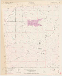 1973 Bachelor Mtn1976 Print · USGSInland Riverside County is shown during a transformative era of water management and rural transition in the early 1970s. Researchers can trace the development of Skinner Reservoir alongside older landmarks like Alamos Sch and the San Diego Aqueduct.
 - 1974 Map of Wildomar, 1977 Print
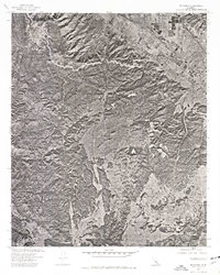 1974 Wildomar1977 Print · USGSWildomar and the surrounding foothills appear during a period of transition in the mid-1970s. Researchers can trace land development and natural drainage patterns through the Santa Ana Mountains and along Slaughterhouse Canyon.
End of results
Showing maps 1-2 of 2
Top cities near Murrieta
- Temecula historical maps
- Menifee historical maps
- Hemet historical maps
- Perris historical maps
- San Jacinto historical maps
- Lake Elsinore historical maps
See more
Top neighborhoods of Murrieta
- Keller Crossing historical maps
- Murrieta Hot Springs historical maps
- Linda Rosa historical maps
- Mapleton historical maps
- California Oaks historical maps
- Spencer's Crossing historical maps
See more
Frequently asked questions
- What are the different types of historical maps available for Murrieta?
- What is the oldest map of Murrieta?
- Where can I purchase historical maps of Murrieta for my home or office?
- Where can I download high-res historical maps of Murrieta?
- Are there historical topographic maps available for Murrieta?
- Is there historical aerial imagery available for Murrieta?
- Where are historical maps of Murrieta sourced from?