1940s Maps of Summit, California
Explore 2 historic maps of Summit from the 1940s. These maps offer a rare glimpse into what life looked like during the 1940s — showing old roads, neighborhoods, homes, and landmarks that have changed or disappeared over time.
Whether you're researching your family's past, planning a metal detecting trip, or studying how Summit's landscape evolved across the 1940s, these high-resolution maps are a powerful tool for exploring the history of this region.
- Focus on a specific era: All maps on this page are from the 1940s, giving you a focused view of this time period.
- See what’s changed: Compare century-old streets, trails, and buildings to today's modern landscape using overlays and satellite layers.
- Research with precision: Use these maps for genealogy, historical research, land use analysis, or educational projects.
- View, download, or print: Maps are fully viewable online in high resolution, and can be downloaded or printed for your own records.
Start exploring Summit's history through authentic maps from the 1940s. This is your window into the past.
Summit, CA maps
(2)- 1940 Map of Canyon Spring, 1957 Print
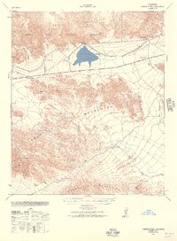 1940 Canyon Spring1957 Print · USGSThe Colorado Desert of Riverside County is captured in this 1940s survey at a time of early infrastructure and ranching. Genealogists and researchers can trace remote water sources and landmarks like Hayfield Reservoir, Shaver Summit, and the Skylark Ranch.2 unique versions available
 - 1943 Map of Canyon Spring, 1944 Print
 1943 Canyon Spring1944 Print · USGSRiverside County's high desert is captured here during the early 1940s, showing the intersection of vital water infrastructure and mountain passes. Researchers can locate remote outposts like Skylark Ranch, trace the route through Shaver Summit, or find isolated water sources at Canyon Spring and Clemens Well.
End of results
Showing maps 1-2 of 2
Frequently asked questions
- What are the different types of historical maps available for Summit?
- What is the oldest map of Summit?
- Where can I purchase historical maps of Summit for my home or office?
- Where can I download high-res historical maps of Summit?
- Are there historical topographic maps available for Summit?
- Is there historical aerial imagery available for Summit?
- Where are historical maps of Summit sourced from?