1960s Maps of Woodcrest, California
Explore 6 historic maps of Woodcrest from the 1960s. These maps offer a rare glimpse into what life looked like during the 1960s — showing old roads, neighborhoods, homes, and landmarks that have changed or disappeared over time.
Whether you're researching your family's past, planning a metal detecting trip, or studying how Woodcrest's landscape evolved across the 1960s, these high-resolution maps are a powerful tool for exploring the history of this region.
- Focus on a specific era: All maps on this page are from the 1960s, giving you a focused view of this time period.
- See what’s changed: Compare century-old streets, trails, and buildings to today's modern landscape using overlays and satellite layers.
- Research with precision: Use these maps for genealogy, historical research, land use analysis, or educational projects.
- View, download, or print: Maps are fully viewable online in high resolution, and can be downloaded or printed for your own records.
Start exploring Woodcrest's history through authentic maps from the 1960s. This is your window into the past.
Woodcrest, CA maps
(6)- 1960 Map of Santa Ana
 1960 Santa Ana1960 Print · USGSSouthern California's coastal plains and inland deserts meet in this mid-century survey of the burgeoning Orange and Riverside county corridors. Researchers can trace the layout of early freeway systems, find tribal lands like the Soboba Indian Reservation, and locate military landmarks such as March Field.2 unique versions available
 - 1965 Map of Santa Ana
 1965 Santa Ana1965 Print · USGSSouthern California is captured in a decade of rapid growth, showing the coastal expansion from Santa Ana down to Oceanside. Genealogists and historians can trace the mid-century development of places like Garden Grove or the rural reaches of Escondido and the Palomar Observatory.
 - 1967 Map of Steele Peak, 1969 Print
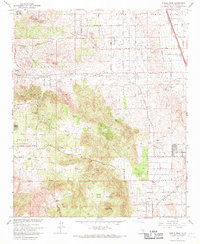 1967 Steele Peak1969 Print · USGSThe semi-arid hills of Riverside County come to life in the late 1960s as residential growth meets old-world mining and military operations. Genealogists and local historians can trace the foundations of Glen Valley, locate the Gavilan Mine, or find rural landmarks like the Good Hope Sch.3 unique versions available
 - 1967 Map of Lake Mathews, 1969 Print
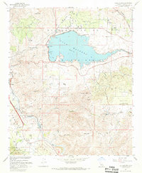 1967 Lake Mathews1969 Print · USGSRiverside County at the end of the sixties reveals a landscape transformed by water infrastructure and historic settlements. Genealogists can trace family roots through the Gavilan Springs Ranch or locate landmarks like the Indian Pictograph Historical Marker and Arcilla.5 unique versions available
 - 1967 Map of Riverside West, 1969 Print
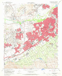 1967 Riverside West1969 Print · USGSRiverside and its western suburbs show a landscape of mid-century growth and deep-rooted institutions during the late sixties. Genealogists and historians can trace the development of Arlington, Casa Blanca, and Pedley while locating landmarks like the Sherman Indian Institute and the Olivewood Cem.4 unique versions available
 - 1967 Map of Riverside East, 1969 Print
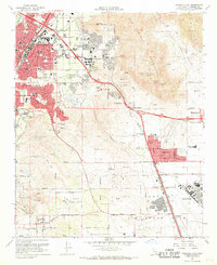 1967 Riverside East1969 Print · USGSRiverside's post-war suburban bloom is captured here as neighborhoods like Edgemont and Sunnymead expand toward the mountains. Trace the foundations of March Air Force Base and the University of California Riverside at a pivotal moment for the region.6 unique versions available
End of results
Showing maps 1-6 of 6
Top cities near Woodcrest
- Riverside historical maps
- Fontana historical maps
- Moreno Valley historical maps
- Ontario historical maps
- Rancho Cucamonga historical maps
- Corona historical maps
See more
Top neighborhoods of Woodcrest
Frequently asked questions
- What are the different types of historical maps available for Woodcrest?
- What is the oldest map of Woodcrest?
- Where can I purchase historical maps of Woodcrest for my home or office?
- Where can I download high-res historical maps of Woodcrest?
- Are there historical topographic maps available for Woodcrest?
- Is there historical aerial imagery available for Woodcrest?
- Where are historical maps of Woodcrest sourced from?