1950s Maps of Woodcrest, California
Explore 6 historic maps of Woodcrest from the 1950s. These maps offer a rare glimpse into what life looked like during the 1950s — showing old roads, neighborhoods, homes, and landmarks that have changed or disappeared over time.
Whether you're researching your family's past, planning a metal detecting trip, or studying how Woodcrest's landscape evolved across the 1950s, these high-resolution maps are a powerful tool for exploring the history of this region.
- Focus on a specific era: All maps on this page are from the 1950s, giving you a focused view of this time period.
- See what’s changed: Compare century-old streets, trails, and buildings to today's modern landscape using overlays and satellite layers.
- Research with precision: Use these maps for genealogy, historical research, land use analysis, or educational projects.
- View, download, or print: Maps are fully viewable online in high resolution, and can be downloaded or printed for your own records.
Start exploring Woodcrest's history through authentic maps from the 1950s. This is your window into the past.
Woodcrest, CA maps
(6)- 1953 Map of Steele Peak, 1955 Print
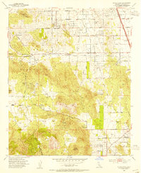 1953 Steele Peak1955 Print · USGSRiverside County at the dawn of the fifties reveals a transition from deep-shaft mining to a burgeoning ranching economy. Researchers can trace historic claims like the Gavilan Mine or explore early local hubs such as Val Verde and the Wagonwheel Ranch.2 unique versions available
 - 1953 Map of Riverside East, 1955 Print
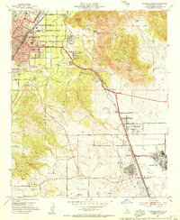 1953 Riverside East1955 Print · USGSRiverside was evolving from a citrus center into a strategic military and educational hub during the mid-fifties. Researchers can trace the layout of March Air Force Base, early campuses like UC Riverside, and local schools such as Fairmont Sch.2 unique versions available
 - 1953 Map of Lake Mathews, 1955 Print
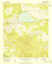 1953 Lake Mathews1955 Print · USGSRiverside County at mid-century reveals a landscape of massive water infrastructure and deep pioneer roots. Trace the path of the Colorado River Aqueduct to Lake Mathews, and locate historic sites like the Cajalco Tin Mine and Arcilla.2 unique versions available
 - 1953 Map of Riverside West, 1955 Print
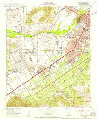 1953 Riverside West1955 Print · USGSRiverside during the early fifties reveals a landscape shaped by historic land grants and a burgeoning citrus and rail economy. Genealogists and researchers can locate family sites near Olivewood Cem, the Sherman Indian Institute, and the Arlington Station rail yard.2 unique versions available
 - 1956 Map of Santa Ana
 1956 Santa Ana1956 Print · USGSSouthern California underwent massive mid-century transformation as suburban growth met major military and water projects. Trace the postwar expansion of Santa Ana and Riverside, the layout of Camp Pendleton, and the path of the Colorado River Aqueduct.
 - 1959 Map of Santa Ana, 1971 Print
 1959 Santa Ana1971 Print · USGSSouthern California is captured in a decade of transformation, from the Orange County coast to the desert floor. Researchers can trace the mid-century footprints of Camp Pendleton, March Air Force Base, and the original Ortega Highway.3 unique versions available
End of results
Showing maps 1-6 of 6
Top cities near Woodcrest
- Riverside historical maps
- Fontana historical maps
- Moreno Valley historical maps
- Ontario historical maps
- Rancho Cucamonga historical maps
- Corona historical maps
See more
Top neighborhoods of Woodcrest
Frequently asked questions
- What are the different types of historical maps available for Woodcrest?
- What is the oldest map of Woodcrest?
- Where can I purchase historical maps of Woodcrest for my home or office?
- Where can I download high-res historical maps of Woodcrest?
- Are there historical topographic maps available for Woodcrest?
- Is there historical aerial imagery available for Woodcrest?
- Where are historical maps of Woodcrest sourced from?