1950s Maps of Sacramento County, California
Explore 39 historic maps of Sacramento County from the 1950s. These maps offer a rare glimpse into what life looked like during the 1950s — showing old roads, neighborhoods, homes, and landmarks that have changed or disappeared over time.
Whether you're researching your family's past, planning a metal detecting trip, or studying how Sacramento County's landscape evolved across the 1950s, these high-resolution maps are a powerful tool for exploring the history of this region.
- Focus on a specific era: All maps on this page are from the 1950s, giving you a focused view of this time period.
- See what’s changed: Compare century-old streets, trails, and buildings to today's modern landscape using overlays and satellite layers.
- Research with precision: Use these maps for genealogy, historical research, land use analysis, or educational projects.
- View, download, or print: Maps are fully viewable online in high resolution, and can be downloaded or printed for your own records.
Start exploring Sacramento County's history through authentic maps from the 1950s. This is your window into the past.
Sacramento County, CA maps
(39)- 1950 Map of Carmichael
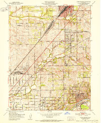
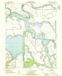
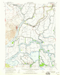
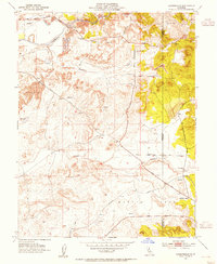
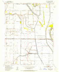
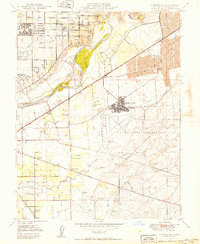 1950 Carmichael1950 Print · USGSThe Sacramento Valley landscape appears here in the years following World War II, defined by the growth of Carmichael and the presence of Mather Field. Researchers can trace early railroad stops like Walsh Station and find family landmarks including Mathew Kilgore Cem and Mayhew Ch.2 unique versions available
 - 1950 Map of Rio Linda, 1955 Print
 1950 Rio Linda1955 Print · USGSNorthern Sacramento at mid-century reveals the growth of Rio Linda and the strategic footprint of the military. Trace the 1950s landscape of McClellan Field, the campus of Grant Tech College, and the rail lines of the Sacramento Northern RR.
 - 1950 Map of Taylor Monument, 1960 Print
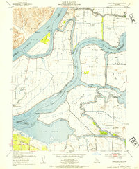
 1950 Taylor Monument1960 Print · USGSThe Sacramento River delta and American Basin are shown here in the mid-century, defined by an intricate system of levees and canals. You can trace the Sacramento Northern rail line and locate rural landmarks like American Basin School and Kiesel.
 - 1951 Map of Taylor Monument
 1951 Taylor Monument1951 Print · USGSThe Sacramento River delta and American Basin are shown at mid-century during a period of significant agricultural and infrastructure development. Trace local family history at Monument Sch, follow the Sacramento Northern rail, or locate the site of Radio Sta KCRA.
 - 1951 Map of Antioch
 1951 Antioch1951 Print · USGSThe Sacramento Delta comes alive in the early fifties as industrial growth meets a complex world of sloughs and islands. Trace family ties to Birds Landing, the Grizzly Island Ferry, or the sprawling grounds of Camp Stoneman.
 - 1951 Map of Rio Linda
 1951 Rio Linda1951 Print · USGSSacramento County's northern outskirts undergo a period of post-war growth as military installations and suburban neighborhoods expand into the valley. Researchers can trace the development of McClellan Field, find family roots at Grant Mem Park, or follow the historic Sacramento Northern rail line.
 - 1951 Map of Citrus Heights, 1952 Print
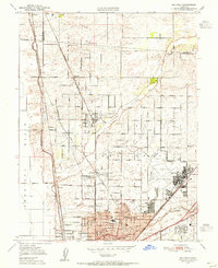
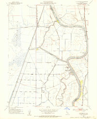
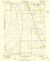
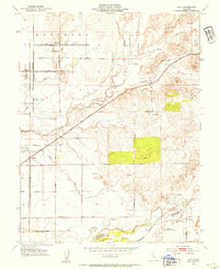
 1951 Citrus Heights1952 Print · USGSNortheast of Sacramento in the early fifties, the landscape was quickly evolving from agricultural ranch lands into bustling suburbs. Genealogists and historians can trace the foundations of Citrus Heights through its early schools like Sylvan Sch and the industrial Dredge Tailings along the American River.3 unique versions available
 - 1952 Map of Isleton, 1953 Print
 1952 Isleton1953 Print · USGSThe Sacramento Delta is captured in the early fifties as a landscape of levees, islands, and riverfront towns. Genealogists and historians can trace Isleton, the historic town of Locke, and local landmarks like Ryer Island Sch and Howard Landing.3 unique versions available
 - 1952 Map of Courtland, 1953 Print
 1952 Courtland1953 Print · USGSThe Sacramento Delta in the early fifties shows a landscape of engineered waterways and island farming communities. Genealogists and historians can trace the development of riverfront towns like Courtland and Locke or follow the Southern Pacific rail line.6 unique versions available
 - 1952 Map of New Hope, 1954 Print
 1952 New Hope1954 Print · USGSThe Sacramento-San Joaquin Delta in the early fifties was a landscape of reclaimed land and vital waterways. Researchers can trace the development of Thornton, locate the New Hope Sch, and follow the Western Pacific rail line through Brack.3 unique versions available
 - 1952 Map of Bouldin Island, 1954 Print
 1952 Bouldin Island1954 Print · USGSThe California Delta in the early fifties was a mosaic of reclaimed tracts and vital shipping lanes. Map collectors and historians can trace the intricate levee systems of Bouldin Island and the isolated Venice-Mandeville School among the sloughs.4 unique versions available
 - 1952 Map of Clarksburg, 1954 Print
 1952 Clarksburg1954 Print · USGSThe Sacramento River delta comes alive in the early 1950s, showing the intersection of heavy industry and ancient landmarks. Trace the agricultural roots of the region through the Sugar Beet Plant, find the Indian Mound, or locate the vanished stops of the Southern Pacific railroad.2 unique versions available
 - 1952 Map of Jersey Island, 1954 Print
 1952 Jersey Island1954 Print · USGSThe Sacramento-San Joaquin River Delta at mid-century is captured here as a sprawling network of leveed islands and tidal sloughs. Genealogists and historians can trace the early roads of Bethel Island or locate the Mayberry Slough Facility Military Reservation and the ferry crossing at Fishermans Cut.3 unique versions available
 - 1952 Map of Courtland, 1959 Print
 1952 Courtland1959 Print · USGSThe Sacramento Delta comes alive in the early fifties, showing a landscape defined by river commerce and sprawling ranch holdings. Family researchers can locate Tremont Cem, Liberty Sch, and long-established properties like Glide Ranch and Maxwell Ranch.3 unique versions available
 - 1952 Map of Rio Vista, 1959 Print
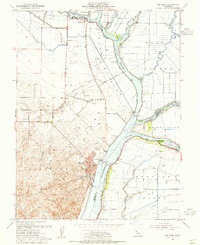
 1952 Rio Vista1959 Print · USGSThe California Delta in the early fifties shows a vibrant network of river towns and island tracts defined by a complex levee system. Genealogists can locate family landmarks from Locke to Bethel Island, including rural anchors like the Beaver Union School and Howard Landing.2 unique versions available
 - 1952 Map of Elk Grove, 1963 Print
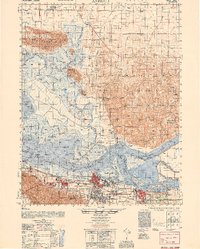
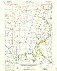
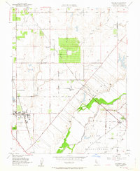 1952 Elk Grove1963 Print · USGSThe Elk Grove area of the Central Valley was a thriving agricultural hub at mid-century, defined by land grants and rail lines. Genealogists can trace family roots through rural landmarks like Reese School, the Central Valleys State Fish Hatchery, and the Union High Sch.3 unique versions available
 - 1953 Map of Lodi North
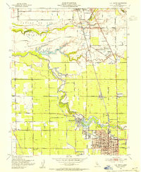 1953 Lodi North1953 Print · USGSNorthern San Joaquin County agriculture is captured here in the early fifties as the region's viticulture and rail networks flourished. Researchers can trace the layout of Lodi, find the Lafayette Sch (Abandoned), or follow the Southern Pacific through Acampo.2 unique versions available
 - 1953 Map of Sloughhouse, 1954 Print
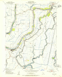
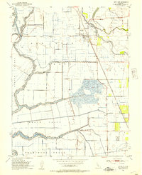
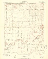
 1953 Sloughhouse1954 Print · USGSThe Cosumnes River valley and its surrounding ranchlands are captured here in the early fifties, showing a rural landscape defined by historic land grants. Genealogists and historians can trace the foundations of Sloughhouse, Wilton, and local schools like Lee School.2 unique versions available
 - 1953 Map of Carbondale, 1954 Print
 1953 Carbondale1954 Print · USGSThe Sacramento and Amador borderlands appear here in the early 1950s, during an era defined by the massive Dredge Tailings along the river. Genealogists and historians can trace the Southern Pacific rail line to Carbondale or locate burials at the Michigan Bar and Live Oak Cemetery.2 unique versions available
 - 1953 Map of Florin, 1954 Print
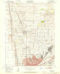
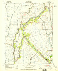
 1953 Florin1954 Print · USGSThe Sacramento Valley in the early fifties shows a landscape of productive vineyards and major rail lines. Researchers can trace the early layout of Florin, the grounds of the County Home for the Aged, and the route of the Western Pacific railroad.2 unique versions available
 - 1953 Map of Galt, 1954 Print
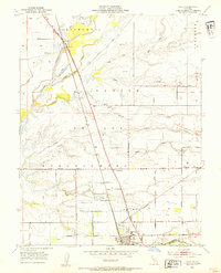 1953 Galt1954 Print · USGSAgricultural life in central California flourished during the early fifties along the steel rails of the Southern Pacific. Genealogists and local historians can trace the rural landscape from Galt to McConnell, locating the Hicksville Cemetery and the Arno School.2 unique versions available
 - 1953 Map of Lockeford, 1954 Print
 1953 Lockeford1954 Print · USGSSan Joaquin County agriculture is in full swing during the early fifties, centered on the river-bend settlements of the Mokelumne Valley. Researchers can trace the path of the Central California Traction railroad and locate family landmarks like Locke Cem and the Bruella Sch.2 unique versions available
 - 1953 Map of Grays Bend, 1954 Print
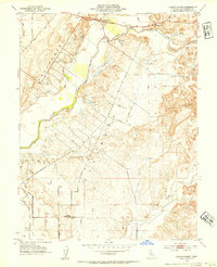
 1953 Grays Bend1954 Print · USGSThe Yolo County floodplains in the early fifties reveal a landscape defined by massive water projects and the Sacramento river-and-rail economy. Researchers can trace the path of the Elkhorn Ferry, the Willow Spring Union School, and the industrial Beet Pulp Silo.4 unique versions available
 - 1953 Map of Clay, 1954 Print
 1953 Clay1954 Print · USGSSacramento and San Joaquin counties in the early fifties show a landscape of thriving ranches and vital rail corridors. Genealogists can trace family landmarks and rural infrastructure at Herald, Colony Sch, and along the Southern Pacific tracks.2 unique versions available
 - 1953 Map of Rio Vista, 1955 Print
 1953 Rio Vista1955 Print · USGSThe Sacramento Delta comes to life in the early 1950s, showcasing a landscape of reclaimed tracts and river life. Trace the development of Rio Vista and the surrounding islands, including Grand Island and Ryer Island, amid a network of sloughs and gas wells.3 unique versions available
Showing maps 1-25 of 39
Top cities of Sacramento County
- Sacramento historical maps
- Elk Grove historical maps
- Citrus Heights historical maps
- Folsom historical maps
- Rancho Cordova historical maps
- Galt historical maps
See more
Frequently asked questions
- What are the different types of historical maps available for Sacramento County?
- What is the oldest map of Sacramento County?
- Where can I purchase historical maps of Sacramento County for my home or office?
- Where can I download high-res historical maps of Sacramento County?
- Are there historical topographic maps available for Sacramento County?
- Is there historical aerial imagery available for Sacramento County?
- Where are historical maps of Sacramento County sourced from?