Old Maps of Sacramento County, California for Metal Detecting
Plan your next treasure hunt with 246 historic maps of Sacramento County. Find old homesites, ghost towns, trails, and gathering spots that may be lost to time — perfect for identifying promising metal detecting locations.
- Locate forgotten sites: Uncover places like long-lost settlements, abandoned rail lines, or gathering spots.
- Plan better hunts: Use map overlays combined with LiDAR or satellite views to narrow in on historically rich areas.
- Made for detectorists: Thousands of hobbyists use these maps to discover relics, coins, and hidden history.
Use these historic maps to boost your research and find new opportunities beneath the surface of Sacramento County.
Sacramento County, CA maps
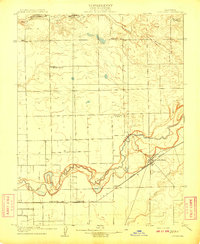
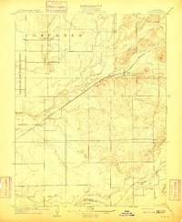
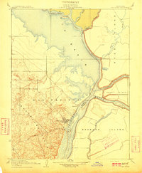
(246)- 1891 Map of Sacramento
 1891 Sacramento1891 Print · USGSNorthern California foothills and the valley plains emerge in the late nineteenth century as the rail-and-road network expands. Trace early family landmarks and river crossings like Mormon Island, Whitney Ranch, and the historic Rattlesnake Bridge.
 - 1892 Map of Sacramento
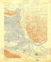
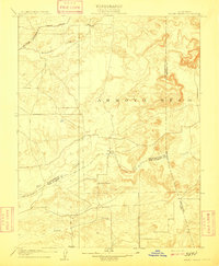
 1892 Sacramento1892 Print · USGSThe rail-and-river economy of Northern California is on full display in the 1890s as the Central Pacific Railroad links the valley to the foothills. Genealogists and historians can trace early settlements like Mormon Island, Salmon Falls, and the Whitney's Ranch before modern development changed the landscape.5 unique versions available
 - 1893 Map of Sacramento, 1900 Print
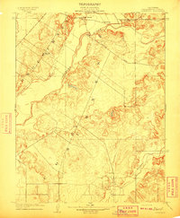
 1893 Sacramento1900 Print · USGSThe Sacramento Valley and Sierra foothills come alive in this late nineteenth-century survey during the height of the railroad era. Researchers can trace the early layout of Roseville, locate family landmarks like Whitney's Ranch, or follow the Placerville Road through the gold country.
 - 1894 Map of Lodi
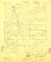
 1894 Lodi1894 Print · USGSThe northern Central Valley and Sierra foothills come alive in the late nineteenth century as railroads reshape the landscape. Local historians can trace early transit hubs like Lodi and Galt alongside rural landmarks like Alabama House and Michigan Bar.3 unique versions available
 - 1902 Map of Fairoaks
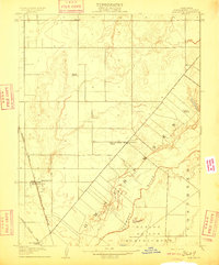
 1902 Fairoaks1902 Print · USGSSacramento and its surrounding ranchlands were undergoing a rapid rail-driven transformation at the start of the century. You can trace the early street grids of Oak Park and Highland Park or locate vanished stops like Twelvemile House and Walsh Station.2 unique versions available
 - 1907 Map of Davisville
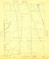
 1907 Davisville1907 Print · USGSYolo and Sacramento counties are captured here at a pivot point for river transit and rail growth. Researchers can trace early rural life via the Lisbon School, Taylor Monument Datey's Ferry, and the original footprint of Davisville.2 unique versions available
 - 1907 Map of Antioch, 1955 Print
 1907 Antioch1955 Print · USGSThe Suisun Bay and Sacramento Delta regions are captured here in the early twentieth century during a period of agricultural and industrial expansion. Local historians can trace family-named river ports like Lingos Landing and rural landmarks such as Scandia School or the settlement of Birds Landing.
 - 1908 Map of Courtland
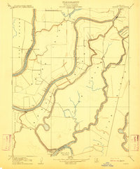
 1908 Courtland1908 Print · USGSThe Sacramento Delta at the dawn of the twentieth century was a landscape of fertile river islands and vital waterborne transit. Genealogists and historians can trace the early footprints of Courtland, Clarksburg, and Freeport, or locate landmarks like the Free County Ferry and Indian Mound.3 unique versions available
 - 1908 Map of Buffalo Creek
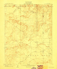
 1908 Buffalo Creek1908 Print · USGSSacramento County ranching and rail history converge in this early century survey of the Rio De Los Americanos. Trace the old Sacramento and Jackson Road and find the Highland School near Deer Creek.
 - 1908 Map of Lockeford
 1908 Lockeford1908 Print · USGSLockeford and the surrounding San Joaquin County plains are shown here at the peak of the rail era. Genealogists can locate family ties at Telegraph School or Brunswick School, and trace the path of the Southern Pacific RR.2 unique versions available
 - 1908 Map of Antioch
 1908 Antioch1908 Print · USGSThe convergence of the great California rivers in the early twentieth century shows a landscape of busy water landings and growing rail towns. Trace the industrial roots of Antioch or locate vanished landings like Palmetto Landing and Duttons Landing along the sloughs.5 unique versions available
 - 1909 Map of Elk Grove
 1909 Elk Grove1909 Print · USGSSacramento County's rural farming landscape is captured here during the first decade of the 1900s, centered on the growing railroad stop of Elk Grove. Genealogists and local historians can trace family locations near the Cosumnes River and find early school sites like Pleasant Grove School and Union School.2 unique versions available
 - 1909 Map of Carbondale
 1909 Carbondale1909 Print · USGSSacramento and Amador counties meet along the river and rail lines in the first decade of the twentieth century. Genealogists can locate established rural centers like Carbondale and Alabama House, alongside local schoolhouses such as Stone House School and Buckeye School.2 unique versions available
 - 1909 Map of Clay
 1909 Clay1909 Print · USGSCentral Valley ranching and rail life are captured here in the early twentieth century as the county line was being formalized. Genealogists can locate family-named schoolhouses like Alabama School and Laguna School along the Southern Pacific line.2 unique versions available
 - 1909 Map of Cosumnes
 1909 Cosumnes1909 Print · USGSSacramento County at the dawn of the twentieth century reveals a landscape of ranching and riverine agriculture. Family historians can locate early educational hubs like Rhoads School and established roadside stops such as the noted Slough House.2 unique versions available
 - 1909 Map of Goose Creek
 1909 Goose Creek1909 Print · USGSThe foothills where Sacramento, Amador, and San Joaquin counties meet are captured here in the years before the Great War. Genealogists and historians can locate the Hutson School and trace the path of the Southern Pacific R. R. (Amador Branch) alongside Dry Creek.2 unique versions available
 - 1909 Map of Florin
 1909 Florin1909 Print · USGSSacramento County rural life is captured in the early twentieth century as the valley floor was being shaped by railroads and irrigation. Genealogists can locate family landmarks like Union House and Prairie School or trace the early paths of Upper Stockton Road.2 unique versions available
 - 1910 Map of New Hope
 1910 New Hope1910 Print · USGSThe California Delta at the start of the twentieth century was a complex network of reclaimed islands and vital waterways. Genealogists and local historians can trace the early community at New Hope and its New Hope School, or locate landings along the Mokelumne River.2 unique versions available
 - 1910 Map of Rio Vista
 1910 Rio Vista1910 Print · USGSThe Sacramento River delta in the early twentieth century was a complex network of island farms and winding waterways. Genealogists and historians can trace old settlements like Rio Vista and Newtown, or locate the specific Blacksmith Shop in the foothills.2 unique versions available
 - 1910 Map of Bouldin
 1910 Bouldin1910 Print · USGSThe Sacramento-San Joaquin Delta at the turn of the century is a labyrinth of reclaimed island tracts and sloughs. Trace the early river landings at Central Landing and Blakes Landing, or locate the Old Cannery along the South Fork Mokelumne River.3 unique versions available
 - 1910 Map of Jersey
 1910 Jersey1910 Print · USGSThe California Delta at the start of the century was a landscape of river-bound islands and vital steamboat landings. Genealogists and historians can trace old waterfront sites like Larsen Landing and Jersey, or the rail path of the A T and S F R R.3 unique versions available
 - 1910 Map of Woodbridge
 1910 Woodbridge1910 Print · USGSSan Joaquin and Sacramento counties are captured here at the height of their early rail-and-river era. Genealogists and historians can trace the early streets of Lodi, the riverside blocks of Woodbridge, and rural landmarks like North School and Tracy Lake.2 unique versions available
 - 1910 Map of Bruceville
 1910 Bruceville1910 Print · USGSThe Sacramento County delta country is captured here in the early twentieth century as a landscape of new railways and traditional wineries. Trace the early days of Bruceville and Bradford Winery, or locate rural landmarks like the Point Pleasant School and Bear Lake.2 unique versions available
 - 1910 Map of Galt
 1910 Galt1910 Print · USGSGalt and the surrounding Sacramento Valley are captured here in the early twentieth century as the railroad transformed rural life. Genealogists and local historians can trace the early rail stops at McConnell and Arno or locate the historic Arno School.2 unique versions available
 - 1910 Map of Isleton
 1910 Isleton1910 Print · USGSThe California Delta's intricate landscape of reclaimed islands and sloughs is captured here just after the turn of the century. You can trace early riverfront settlements like Isleton and Walnut Grove, or locate the waterfront Golden State Cannery.3 unique versions available
Showing maps 1-25 of 246
Top cities of Sacramento County
- Sacramento historical maps
- Elk Grove historical maps
- Citrus Heights historical maps
- Folsom historical maps
- Rancho Cordova historical maps
- Galt historical maps
See more
Frequently asked questions
- What are the different types of historical maps available for Sacramento County?
- What is the oldest map of Sacramento County?
- Where can I purchase historical maps of Sacramento County for my home or office?
- Where can I download high-res historical maps of Sacramento County?
- Are there historical topographic maps available for Sacramento County?
- Is there historical aerial imagery available for Sacramento County?
- Where are historical maps of Sacramento County sourced from?