1930s Maps of Sacramento County, California
Explore 2 historic maps of Sacramento County from the 1930s. These maps offer a rare glimpse into what life looked like during the 1930s — showing old roads, neighborhoods, homes, and landmarks that have changed or disappeared over time.
Whether you're researching your family's past, planning a metal detecting trip, or studying how Sacramento County's landscape evolved across the 1930s, these high-resolution maps are a powerful tool for exploring the history of this region.
- Focus on a specific era: All maps on this page are from the 1930s, giving you a focused view of this time period.
- See what’s changed: Compare century-old streets, trails, and buildings to today's modern landscape using overlays and satellite layers.
- Research with precision: Use these maps for genealogy, historical research, land use analysis, or educational projects.
- View, download, or print: Maps are fully viewable online in high resolution, and can be downloaded or printed for your own records.
Start exploring Sacramento County's history through authentic maps from the 1930s. This is your window into the past.
Sacramento County, CA maps
(2)- 1939 Map of Lodi, 1957 Print
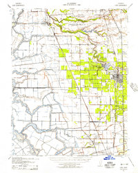 1939 Lodi1957 Print · USGSThe San Joaquin Delta during the late 1930s shows a landscape of reclaimed islands and a bustling rail-and-river economy. Genealogists and historians can trace old rural school districts like Ray District Sch and landmarks such as the New Hope Migratory Labor Camp.2 unique versions available
 - 1939 Map of Bellota, 1958 Print
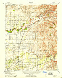 1939 Bellota1958 Print · USGSThis late 1930s survey of the San Joaquin Valley captures a landscape of fertile river bottoms and emerging rail corridors. Genealogists and historians can trace numerous rural schoolhouses and rail stops like Lockeford, Elliott, and the Central California Traction line.2 unique versions available
End of results
Showing maps 1-2 of 2
Top cities of Sacramento County
- Sacramento historical maps
- Elk Grove historical maps
- Citrus Heights historical maps
- Folsom historical maps
- Rancho Cordova historical maps
- Galt historical maps
See more
Frequently asked questions
- What are the different types of historical maps available for Sacramento County?
- What is the oldest map of Sacramento County?
- Where can I purchase historical maps of Sacramento County for my home or office?
- Where can I download high-res historical maps of Sacramento County?
- Are there historical topographic maps available for Sacramento County?
- Is there historical aerial imagery available for Sacramento County?
- Where are historical maps of Sacramento County sourced from?