1990s Maps of Sacramento County, California
Explore 9 historic maps of Sacramento County from the 1990s. These maps offer a rare glimpse into what life looked like during the 1990s — showing old roads, neighborhoods, homes, and landmarks that have changed or disappeared over time.
Whether you're researching your family's past, planning a metal detecting trip, or studying how Sacramento County's landscape evolved across the 1990s, these high-resolution maps are a powerful tool for exploring the history of this region.
- Focus on a specific era: All maps on this page are from the 1990s, giving you a focused view of this time period.
- See what’s changed: Compare century-old streets, trails, and buildings to today's modern landscape using overlays and satellite layers.
- Research with precision: Use these maps for genealogy, historical research, land use analysis, or educational projects.
- View, download, or print: Maps are fully viewable online in high resolution, and can be downloaded or printed for your own records.
Start exploring Sacramento County's history through authentic maps from the 1990s. This is your window into the past.
Sacramento County, CA maps
(9)- 1992 Map of Rio Linda, 1997 Print
 1992 Rio Linda1997 Print · USGSThe northern Sacramento suburbs and the massive Mc Clellan Air Force Base are shown here in the early nineties. Researchers can trace the development of Rio Linda, locate the Sunset Lawn Cemetery, or find rural landmarks like the Elverta Switchyard.
 - 1992 Map of Citrus Heights, 1997 Print
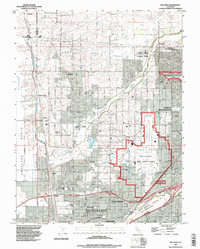
 1992 Citrus Heights1997 Print · USGSGreater Sacramento's northeastern suburbs were rapidly maturing in the early nineties, showing a dense grid of neighborhoods between Roseville and the American River. Researchers can trace the perimeter of Mc Clellan Air Force Base and locate local landmarks like American River College and Sylvan Corners.
 - 1992 Map of Sacramento East, 1997 Print
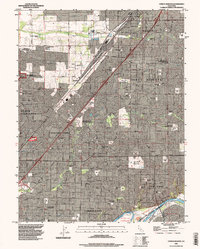
 1992 Sacramento East1997 Print · USGSSacramento and its eastern suburbs are captured in the early nineties as a bustling hub of state government and military logistics. Researchers can trace historic burial grounds like East Lawn Cemetery or locate landmarks such as Sutters Fort State Historic Park and the Sacramento Army Depot.
 - 1992 Map of Sacramento West, 1997 Print
 1992 Sacramento West1997 Print · USGSSacramento and its western neighbor are seen here in the early 1990s as the riverfront continued to transition from industry to preservation. Researchers can trace the massive Deep Water Ship Channel and find local landmarks like Old Sacramento State Historical Park and William Land Park.
 - 1992 Map of Carmichael, 1997 Print
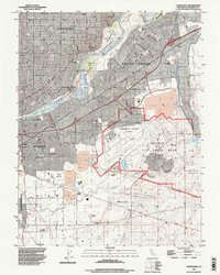 1992 Carmichael1997 Print · USGSThe Sacramento suburbs of Carmichael and Rancho Cordova are shown here in the 1990s, split by the American River. Researchers can locate Mather Air Force Base and historic burial sites like the Mathew Kilgore Cemetery or the community of Walsh Station.
 - 1993 Map of Lodi, 1994 Print
 1993 Lodi1994 Print · USGSNorthern California's delta country and the growing Central Valley corridors are captured here in the early nineties. Genealogists and historians can trace the intricate island tracts, old railroad lines like the Sacramento Northern RR, and established local landmarks including the Lodi Memorial Cemetery and University of the Pacific.2 unique versions available
 - 1994 Map of Sacramento
 1994 Sacramento1994 Print · USGSThe Sacramento valley was a landscape of massive flood control and military aviation during the mid-nineties. Researchers can trace the complex network of the Yolo Bypass and the Sacramento River alongside McClellan Air Force Base and Zamora.2 unique versions available
 - 1997 Map of Bouldin Island, 1998 Print
 1997 Bouldin Island1998 Print · USGSThe heart of the Sacramento-San Joaquin River Delta is captured in the late twentieth century as a complex maze of reclaimed islands and managed waterways. Trace the industrial reach of the Stockton Deep Water Channel or explore the recreational boundaries of Franks Tract.
 - 1997 Map of Goose Creek, 2002 Print
 1997 Goose Creek2002 Print · USGSSacramento and San Joaquin counties meet in this rural landscape during the late nineties, where hydraulic history is etched into the earth. Genealogists and historians can trace the old community of Hadselville and examine the extensive Dredge Tailings along the banks of Dry Creek.
End of results
Showing maps 1-9 of 9
Top cities of Sacramento County
- Sacramento historical maps
- Elk Grove historical maps
- Citrus Heights historical maps
- Folsom historical maps
- Rancho Cordova historical maps
- Galt historical maps
See more
Frequently asked questions
- What are the different types of historical maps available for Sacramento County?
- What is the oldest map of Sacramento County?
- Where can I purchase historical maps of Sacramento County for my home or office?
- Where can I download high-res historical maps of Sacramento County?
- Are there historical topographic maps available for Sacramento County?
- Is there historical aerial imagery available for Sacramento County?
- Where are historical maps of Sacramento County sourced from?