1970s Maps of Apple Valley, California
Explore 3 historic maps of Apple Valley from the 1970s. These maps offer a rare glimpse into what life looked like during the 1970s — showing old roads, neighborhoods, homes, and landmarks that have changed or disappeared over time.
Whether you're researching your family's past, planning a metal detecting trip, or studying how Apple Valley's landscape evolved across the 1970s, these high-resolution maps are a powerful tool for exploring the history of this region.
- Focus on a specific era: All maps on this page are from the 1970s, giving you a focused view of this time period.
- See what’s changed: Compare century-old streets, trails, and buildings to today's modern landscape using overlays and satellite layers.
- Research with precision: Use these maps for genealogy, historical research, land use analysis, or educational projects.
- View, download, or print: Maps are fully viewable online in high resolution, and can be downloaded or printed for your own records.
Start exploring Apple Valley's history through authentic maps from the 1970s. This is your window into the past.
Apple Valley, CA maps
(3)- 1970 Map of Apple Valley North, 1974 Print
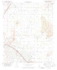 1970 Apple Valley North1974 Print · USGSApple Valley was undergoing significant suburban expansion in the early seventies, blending residential growth with its traditional mining roots. Genealogists and local historians can trace the early neighborhood layouts near Navajo Sch or locate landmarks like the Apple Valley Country Club and the Mojave Northern railroad.5 unique versions available
 - 1970 Map of Turtle Valley, 1975 Print
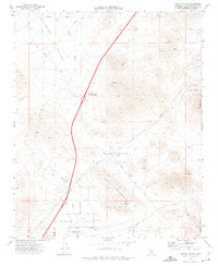 1970 Turtle Valley1975 Print · USGSThe High Desert region around Bell Mountain in the 1970s reveals a landscape shaped by mining and desert transit. Genealogists and historians can trace the intersection of early routes like Mission Road and remote mineral sites such as the Bobcat Mine.3 unique versions available
 - 1971 Map of Apple Valley South, 1975 Print
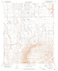 1971 Apple Valley South1975 Print · USGSApple Valley was undergoing a period of high desert expansion in the early 1970s as new residential grids pushed toward the mountains. Researchers can trace local development through landmarks like Jess Ranch, the Lone Wolf Colony, and the Mariana Sch.7 unique versions available
End of results
Showing maps 1-3 of 3
Top cities near Apple Valley
- Victorville historical maps
- Hesperia historical maps
- Adelanto historical maps
- Oak Hills historical maps
Top neighborhoods of Apple Valley
- Bell Mountain historical maps
- Sunset Hills historical maps
- Desert Knolls historical maps
- Cotners Corner historical maps
- Lone Wolf Colony historical maps
- Desert Knolls Manor historical maps
Frequently asked questions
- What are the different types of historical maps available for Apple Valley?
- What is the oldest map of Apple Valley?
- Where can I purchase historical maps of Apple Valley for my home or office?
- Where can I download high-res historical maps of Apple Valley?
- Are there historical topographic maps available for Apple Valley?
- Is there historical aerial imagery available for Apple Valley?
- Where are historical maps of Apple Valley sourced from?