2020s Maps of Earp, Bluewater
Explore 1 historic maps of Earp from the 2020s. These maps offer a rare glimpse into what life looked like during the 2020s — showing old roads, neighborhoods, homes, and landmarks that have changed or disappeared over time.
Whether you're researching your family's past, planning a metal detecting trip, or studying how Earp's landscape evolved across the 2020s, these high-resolution maps are a powerful tool for exploring the history of this region.
- Focus on a specific era: All maps on this page are from the 2020s, giving you a focused view of this time period.
- See what’s changed: Compare century-old streets, trails, and buildings to today's modern landscape using overlays and satellite layers.
- Research with precision: Use these maps for genealogy, historical research, land use analysis, or educational projects.
- View, download, or print: Maps are fully viewable online in high resolution, and can be downloaded or printed for your own records.
Start exploring Earp's history through authentic maps from the 2020s. This is your window into the past.
Earp, Bluewater maps
(1)- 2021 Map of Parker, 2021 Print
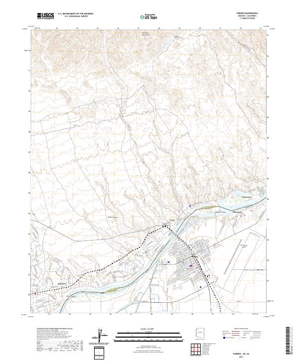 2021 Parker2021 Print · USGSThe Colorado River borderlands in the early 2020s reveal a landscape defined by desert water management and the growth of the Parker community. Trace the intricate desert canals near Big River or locate the La Paz County Courthouse and Avi Suquilla Airport.
End of results
Showing maps 1-1 of 1
Top cities near Earp
- Parker historical maps
- Parker historical maps
- Cienega Springs historical maps
- Big River historical maps
- Bouse historical maps
- Bluewater historical maps
See more
Frequently asked questions
- What are the different types of historical maps available for Earp?
- What is the oldest map of Earp?
- Where can I purchase historical maps of Earp for my home or office?
- Where can I download high-res historical maps of Earp?
- Are there historical topographic maps available for Earp?
- Is there historical aerial imagery available for Earp?
- Where are historical maps of Earp sourced from?