1940s Maps of Phelan, California
Explore 3 historic maps of Phelan from the 1940s. These maps offer a rare glimpse into what life looked like during the 1940s — showing old roads, neighborhoods, homes, and landmarks that have changed or disappeared over time.
Whether you're researching your family's past, planning a metal detecting trip, or studying how Phelan's landscape evolved across the 1940s, these high-resolution maps are a powerful tool for exploring the history of this region.
- Focus on a specific era: All maps on this page are from the 1940s, giving you a focused view of this time period.
- See what’s changed: Compare century-old streets, trails, and buildings to today's modern landscape using overlays and satellite layers.
- Research with precision: Use these maps for genealogy, historical research, land use analysis, or educational projects.
- View, download, or print: Maps are fully viewable online in high resolution, and can be downloaded or printed for your own records.
Start exploring Phelan's history through authentic maps from the 1940s. This is your window into the past.
Phelan, CA maps
(3)- 1942 Map of San Antonio
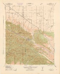 1942 San Antonio1942 Print · USGSThe high San Gabriel Mountains meet the Mojave Desert in the early 1940s, showing a rugged landscape of ranching and early mountain recreation. Genealogists and local historians can trace family lands like Smith Ranch and Nuss Ranch, or locate landmarks like the Smithsonian Observatory and Wrightwood.4 unique versions available
 - 1942 Map of Hesperia
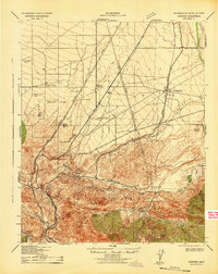 1942 Hesperia1942 Print · USGSSan Bernardino County ranchlands and mountain passes are captured here during the early years of the war. Genealogists and historians can trace the Atchison Topeka and Santa Fe rail line as it climbs toward Cajon Pass and the Cajon Summit Lookout.
 - 1942 Map of Shadow Mountains
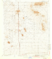 1942 Shadow Mountains1942 Print · USGSThe High Desert at the start of the war reveals a landscape of isolated homesteads and early aviation landmarks. Genealogists and desert historians can locate family outposts like Walton Place and Hess Ranch or trace the early Palmdale Victorville Road.2 unique versions available
End of results
Showing maps 1-3 of 3
Top cities near Phelan
- Victorville historical maps
- Hesperia historical maps
- Adelanto historical maps
- Oak Hills historical maps
- Piñon Hills historical maps
- Wrightwood historical maps
Top neighborhoods of Phelan
Frequently asked questions
- What are the different types of historical maps available for Phelan?
- What is the oldest map of Phelan?
- Where can I purchase historical maps of Phelan for my home or office?
- Where can I download high-res historical maps of Phelan?
- Are there historical topographic maps available for Phelan?
- Is there historical aerial imagery available for Phelan?
- Where are historical maps of Phelan sourced from?