1990s Maps of Phelan, California
Explore 3 historic maps of Phelan from the 1990s. These maps offer a rare glimpse into what life looked like during the 1990s — showing old roads, neighborhoods, homes, and landmarks that have changed or disappeared over time.
Whether you're researching your family's past, planning a metal detecting trip, or studying how Phelan's landscape evolved across the 1990s, these high-resolution maps are a powerful tool for exploring the history of this region.
- Focus on a specific era: All maps on this page are from the 1990s, giving you a focused view of this time period.
- See what’s changed: Compare century-old streets, trails, and buildings to today's modern landscape using overlays and satellite layers.
- Research with precision: Use these maps for genealogy, historical research, land use analysis, or educational projects.
- View, download, or print: Maps are fully viewable online in high resolution, and can be downloaded or printed for your own records.
Start exploring Phelan's history through authentic maps from the 1990s. This is your window into the past.
Phelan, CA maps
(3)- 1996 Map of Phelan, 1999 Print
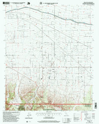 1996 Phelan1999 Print · USGSThe high desert community of Phelan is shown here during its late-twentieth-century development, where ranching legacies meet state-scale water projects. Trace historic family lands like Johnson Ranch and Buttemer Ranch or the path of the California Aqueduct.
 - 1996 Map of Cajon, 1999 Print
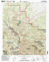 1996 Cajon1999 Print · USGSThe San Bernardino mountains during the 1990s reveal a landscape dominated by the engineering of the Santa Fe and Southern Pacific railroads. Researchers can trace the narrow mountain settlements at Cosy Dell, the historic Little Horsethief Ranch, and the path of the Pacific Crest National Scenic Trail.
 - 1996 Map of Baldy Mesa, 1999 Print
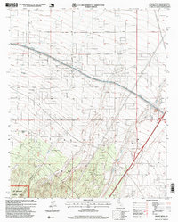 1996 Baldy Mesa1999 Print · USGSThe High Desert region south of Victorville is captured here in the mid-1990s as suburban growth began to meet traditional ranching lands. Genealogists and local historians can trace family-named sites like Fish Ranch and White Ranch near the San Bernardino National Forest boundary.
End of results
Showing maps 1-3 of 3
Top cities near Phelan
- Victorville historical maps
- Hesperia historical maps
- Adelanto historical maps
- Oak Hills historical maps
- Piñon Hills historical maps
- Wrightwood historical maps
Top neighborhoods of Phelan
Frequently asked questions
- What are the different types of historical maps available for Phelan?
- What is the oldest map of Phelan?
- Where can I purchase historical maps of Phelan for my home or office?
- Where can I download high-res historical maps of Phelan?
- Are there historical topographic maps available for Phelan?
- Is there historical aerial imagery available for Phelan?
- Where are historical maps of Phelan sourced from?