1990s Maps of Venus, California
Explore 2 historic maps of Venus from the 1990s. These maps offer a rare glimpse into what life looked like during the 1990s — showing old roads, neighborhoods, homes, and landmarks that have changed or disappeared over time.
Whether you're researching your family's past, planning a metal detecting trip, or studying how Venus's landscape evolved across the 1990s, these high-resolution maps are a powerful tool for exploring the history of this region.
- Focus on a specific era: All maps on this page are from the 1990s, giving you a focused view of this time period.
- See what’s changed: Compare century-old streets, trails, and buildings to today's modern landscape using overlays and satellite layers.
- Research with precision: Use these maps for genealogy, historical research, land use analysis, or educational projects.
- View, download, or print: Maps are fully viewable online in high resolution, and can be downloaded or printed for your own records.
Start exploring Venus's history through authentic maps from the 1990s. This is your window into the past.
Venus, CA maps
(2)- 1993 Map of Soda Mountains
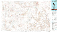 1993 Soda Mountains1993 Print · USGSSan Bernardino County's high desert reveals its military and mining foundations in the 1990s. Trace the expanses of Fort Irwin or locate historic operations like the Goldstone Mine and Silver Lake Mine along the Union Pacific Railroad.
 - 1996 Map of Paradise Range, 1998 Print
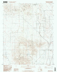 1996 Paradise Range1998 Print · USGSThe Paradise Range in the mid-1990s reveals a unique desert intersection of Cold War era space communication and historic mining. Researchers can locate remote sites like the Goldstone Deep Space Complex alongside the Gold Divide Mine and Paradise Springs.
End of results
Showing maps 1-2 of 2
Top cities near Venus
Frequently asked questions
- What are the different types of historical maps available for Venus?
- What is the oldest map of Venus?
- Where can I purchase historical maps of Venus for my home or office?
- Where can I download high-res historical maps of Venus?
- Are there historical topographic maps available for Venus?
- Is there historical aerial imagery available for Venus?
- Where are historical maps of Venus sourced from?