1940s Maps of Rainbow, California
Explore 8 historic maps of Rainbow from the 1940s. These maps offer a rare glimpse into what life looked like during the 1940s — showing old roads, neighborhoods, homes, and landmarks that have changed or disappeared over time.
Whether you're researching your family's past, planning a metal detecting trip, or studying how Rainbow's landscape evolved across the 1940s, these high-resolution maps are a powerful tool for exploring the history of this region.
- Focus on a specific era: All maps on this page are from the 1940s, giving you a focused view of this time period.
- See what’s changed: Compare century-old streets, trails, and buildings to today's modern landscape using overlays and satellite layers.
- Research with precision: Use these maps for genealogy, historical research, land use analysis, or educational projects.
- View, download, or print: Maps are fully viewable online in high resolution, and can be downloaded or printed for your own records.
Start exploring Rainbow's history through authentic maps from the 1940s. This is your window into the past.
Rainbow, CA maps
(8)- 1942 Map of Temecula
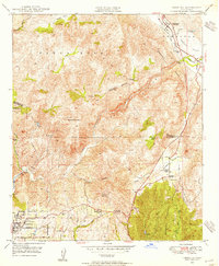
 1942 Temecula1942 Print · USGSNorthern San Diego County and southern Riverside County are mapped here in the early 1940s, showing a rural landscape of canyons and ranch lands. Genealogists can trace family holdings at San Luis Rey Rancho or find early schools like Lilac Valley Sch.
 - 1947 Map of Santa Ana, 1949 Print
 1947 Santa Ana1949 Print · USGSSouthern California is depicted here in the late forties, showing the expansion of the Inland Empire and the Orange County coast. Researchers can trace the early layout of Palm Springs or locate long-standing tribal lands like the Pala Indian Reservation and Rincon Indian Res.
 - 1948 Map of Temecula, 1955 Print
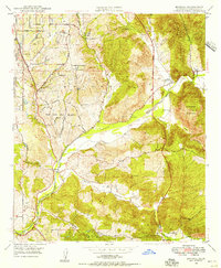
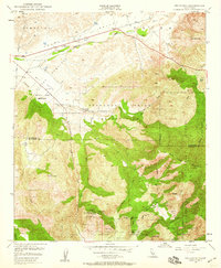
 1948 Temecula1955 Print · USGSThe inland canyons between Riverside and San Diego Counties come alive in this post-war survey. Genealogists and historians can trace old property lines at Swanguen Ranch and Royal Oak Ranch, or find the Vallecitos Sch in Rainbow.2 unique versions available
 - 1948 Map of Bonsall, 1956 Print
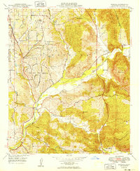
 1948 Bonsall1956 Print · USGSBonsall and the San Luis Rey River valley are shown here just after the war, when the landscape was a mix of working cattle ranches and emerging residential heights. Genealogists and local historians can locate early landmarks like Duffy Ranch Sch, Dulin Ranch, and the Fallbrook Naval Reservation.2 unique versions available
 - 1949 Map of Bonsall
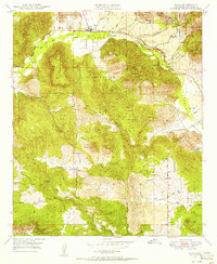
 1949 Bonsall1949 Print · USGSNorthern San Diego County is captured here in the late 1940s as a landscape of large ranches and riverside settlements. Genealogists can trace property and community roots near Bonsall, the Duffy Ranch Sch, and the extensive Circle R Ranch.
 - 1949 Map of Santa Ana
 1949 Santa Ana1949 Print · USGSSouthern California underwent a profound transformation in the late 1940s as military installations and citrus groves shared the landscape. Researchers can trace early coastal growth at Laguna Beach, military history at Camp Pendleton, and the rail corridors of the Pacific Electric.
 - 1949 Map of Pala, 1956 Print
 1949 Pala1956 Print · USGSNorthern San Diego County in the late 1940s is shown here as a landscape of remote mountain ranches and tribal lands. Researchers can trace the path of the San Diego Aqueduct or locate family history at the Pala Indian Reservation and Agua Tibia Ranch.2 unique versions available
 - 1949 Map of Pechanga, 1959 Print
 1949 Pechanga1959 Print · USGSThe Riverside and San Diego county line in the late 1940s was a hub of gemstone mining and traditional ranching. Local researchers can locate historic mining operations like the Tourmaline Queen Mine or trace family sites at Pauba Ranch and San Gabriel Church.2 unique versions available
End of results
Showing maps 1-8 of 8
Top cities near Rainbow
- Oceanside historical maps
- Escondido historical maps
- Carlsbad historical maps
- Murrieta historical maps
- Temecula historical maps
- Vista historical maps
See more
Frequently asked questions
- What are the different types of historical maps available for Rainbow?
- What is the oldest map of Rainbow?
- Where can I purchase historical maps of Rainbow for my home or office?
- Where can I download high-res historical maps of Rainbow?
- Are there historical topographic maps available for Rainbow?
- Is there historical aerial imagery available for Rainbow?
- Where are historical maps of Rainbow sourced from?