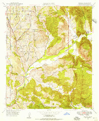
1948 Map of Bonsall
USGS Topo · Published 1956About this map
The San Luis Rey River winds through this post-war landscape, acting as a geographic anchor for the rural communities and ranches of northern San Diego County. During this period, the area around Bonsall and San Luis Rey Heights remained largely defined by agriculture and large landholdings, including Rancho Viejo and Circle R Ranch. The presence of the Duffy Ranch Sch and the secluded residential pocket of Winterwarm reflect a transition toward suburban-rural living. In the northwest, the Fallbrook Naval Reservation marks a significant military footprint adjacent to the leisure grounds of Live Oak Park. The terrain is dominated by prominent heights such as Monserate Mountain and Mt Ararat, which overlook a network of canyons including Moosa Canyon and Gopher Canyon, illustrating the complex drainage patterns that shaped early regional road placement.
Find a feature on this map
27 named features on this map. Tap any name to fly to it.
Don’t see what you’re looking for? This feature index may not catch every label — zoom into the map to look around manually.
Map Details
Editions of this 1948 Bonsall Map
2 editions found
Other maps of this area

1893 · Oceanside
USGS Topo · 1:62,500

1893 · Escondido
USGS Topo · 1:62,500

1898 · Oceanside
USGS Topo · 1:62,500

1901 · Escondido
USGS Topo · 1:62,500

1901 · Oceanside
USGS Topo · 1:62,500

1901 · San Luis Rey
USGS Topo · 1:125,000

1904 · Southern California Sheet No. 2
USGS Topo · 1:250,000

1941 · Margarita Peak
USGS Topo · 1:62,500

1942 · Margarita Peak
USGS Topo · 1:62,500

1942 · Temecula
USGS Topo · 1:62,500