1950s Maps of Peters, California
Explore 3 historic maps of Peters from the 1950s. These maps offer a rare glimpse into what life looked like during the 1950s — showing old roads, neighborhoods, homes, and landmarks that have changed or disappeared over time.
Whether you're researching your family's past, planning a metal detecting trip, or studying how Peters's landscape evolved across the 1950s, these high-resolution maps are a powerful tool for exploring the history of this region.
- Focus on a specific era: All maps on this page are from the 1950s, giving you a focused view of this time period.
- See what’s changed: Compare century-old streets, trails, and buildings to today's modern landscape using overlays and satellite layers.
- Research with precision: Use these maps for genealogy, historical research, land use analysis, or educational projects.
- View, download, or print: Maps are fully viewable online in high resolution, and can be downloaded or printed for your own records.
Start exploring Peters's history through authentic maps from the 1950s. This is your window into the past.
Peters, CA maps
(3)- 1952 Map of Peters, 1953 Print
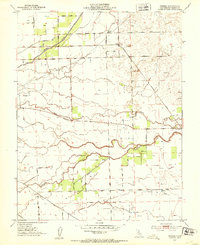 1952 Peters1953 Print · USGSAgricultural life in eastern San Joaquin County during the early fifties revolved around the small hubs of Peters and Farmington. Genealogists and historians can trace family land via Everett School, a local Cem, and rural routes like Van Allen Road.5 unique versions available
 - 1952 Map of Manteca, 1958 Print
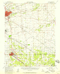 1952 Manteca1958 Print · USGSThe fertile San Joaquin Valley underwent significant post-war growth as irrigation and railroads connected agricultural hubs in the early fifties. Genealogists and local historians can trace rural school districts like Four Trees School and find industry landmarks such as the Sugar Refinery or the Union Memorial Cemetery.2 unique versions available
 - 1956 Map of San Jose
 1956 San Jose1956 Print · USGSCentral California in the mid-fifties reveals the transition from sprawling orchards to growing urban hubs like San Jose and Stockton. Genealogists and historians can trace the rail-era landscape of the Mother Lode through Chinese Camp and Tuttletown, or follow the water through the Joaquin River and Calaveras Reservoir.
End of results
Showing maps 1-3 of 3
Top cities near Peters
- Stockton historical maps
- Manteca historical maps
- Lodi historical maps
- Oakdale historical maps
- Lathrop historical maps
- Ripon historical maps
See more
Frequently asked questions
- What are the different types of historical maps available for Peters?
- What is the oldest map of Peters?
- Where can I purchase historical maps of Peters for my home or office?
- Where can I download high-res historical maps of Peters?
- Are there historical topographic maps available for Peters?
- Is there historical aerial imagery available for Peters?
- Where are historical maps of Peters sourced from?