Old Maps of Vernalis, California for Hiking & Exploration
Hike through history with 15 historic maps of Vernalis. Explore old trails, ghost towns, and forgotten backroads — perfect for outdoor adventurers and local explorers.
- Rediscover forgotten places: Map out old mining camps, roads, and footpaths that no longer exist on modern maps.
- Layer with modern tools: Combine with LiDAR or satellite views to plan hikes through historical terrain.
- Made for exploration: Popular among hikers, overlanders, and local history lovers.
Use these maps to find adventure and explore the hidden past of Vernalis.
Vernalis, CA maps
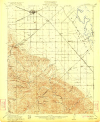
(15)- 1915 Map of Vernalis
 1915 Vernalis1915 Print · USGSThe San Joaquin Valley at the onset of the Great War reveals a landscape transitioning from river-bound trade to a rail-centric economy. Trace the development of San Joaquin City and the rural New Jerusalem School along the tracks of the Southern Pacific.
 - 1922 Map of Carbona
 1922 Carbona1922 Print · USGSSan Joaquin County at the dawn of the roaring twenties reveals a bustling rail landscape where the Southern Pacific meets the Western Pacific. Genealogists and historians can trace early school districts like New Jerusalem School and find industrial roots at the Buckeye Mines.3 unique versions available
 - 1942 Map of Carbona
 1942 Carbona1942 Print · USGSThe rail-and-river landscape of the San Joaquin Valley is captured here just as Tracy was expanding into a regional hub. Genealogists and historians can trace the rural school system through New Jerusalem School and find local landmarks like the Brichetto Tomb and Buckeye Mines.
 - 1947 Map of San Jose, 1948 Print
 1947 San Jose1948 Print · USGSNorthern California's heartland is captured here just after the war, showing the rapid growth of the Santa Clara and Central Valleys. Researchers can trace the legacy of rail and water at Castle Air Force Base, Stockton, and the Hetch Hetchy Aqueduct.
 - 1952 Map of Vernalis, 1954 Print
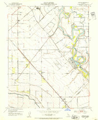 1952 Vernalis1954 Print · USGSThe San Joaquin riverfront is shown at a mid-century turning point when major water projects and rail lines reshaped the Central Valley. Genealogists and historians can trace the San Joaquin City (Site), the New Jerusalem School, and crossings like Durham Ferry Road.3 unique versions available
 - 1956 Map of San Jose
 1956 San Jose1956 Print · USGSCentral California in the mid-fifties reveals the transition from sprawling orchards to growing urban hubs like San Jose and Stockton. Genealogists and historians can trace the rail-era landscape of the Mother Lode through Chinese Camp and Tuttletown, or follow the water through the Joaquin River and Calaveras Reservoir.
 - 1962 Map of San Jose
 1962 San Jose1962 Print · USGSCentral California in the early sixties showcases the expansion of the San Joaquin and Santa Clara valleys. Researchers can trace the rail-to-road transition along the Southern Pacific RR or locate landmarks like Castle USAF Base and Loma Prieta.4 unique versions available
 - 1966 Map of San Jose
 1966 San Jose1966 Print · USGSCentral California in the mid-1960s reveals a landscape of massive irrigation projects and expanding Cold War military footprints. Researchers can trace the rail-and-river network of the San Joaquin Valley or locate specialized sites like Castle Air Force Base and the Sharp General Depot (Military).
 - 1969 Map of Vernalis, 1972 Print
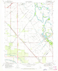 1969 Vernalis1972 Print · USGSThe San Joaquin River valley was a hub of massive water engineering and ranching in the late sixties. Trace the routes of the California Aqueduct and Hetch Hetchy Aqueduct or find historic locales like the San Joaquin City (Site).2 unique versions available
 - 1989 Map of Stockton
 1989 Stockton1989 Print · USGSDuring the late 1980s, the California Delta and San Joaquin Valley saw a massive convergence of water infrastructure and military logistics. Researchers can trace the sprawling Lawrence Livermore Laboratory (Univ of Calif) and Sharpe Army Depot alongside the complex waterways of Union Island and Victoria Island.2 unique versions available
 - 1991 Map of Vernalis, 1995 Print
 1991 Vernalis1995 Print · USGSThe San Joaquin Valley landscape comes into focus here in the early nineties, showing a region defined by its massive water projects and river heritage. Researchers can trace the path of the California Aqueduct or locate rural landmarks like Vernalis and the New Jerusalem Sch.
 - 2012 Map of Vernalis, 2012 Print
 2012 Vernalis2012 Print · USGSCovers Vernalis, including Cochrane, San Joaquin River Club, and other nearby areas
 - 2015 Map of Vernalis, 2015 Print
 2015 Vernalis2015 Print · USGSCovers Vernalis, including Cochrane, San Joaquin River Club, and other nearby areas
 - 2018 Map of Vernalis, 2018 Print
 2018 Vernalis2018 Print · USGSCovers Vernalis, including Cochrane, San Joaquin River Club, and other nearby areas
 - 2021 Map of Vernalis, 2021 Print
 2021 Vernalis2021 Print · USGSThe San Joaquin Valley's intricate water network and small agricultural hubs are on display in this contemporary survey. Genealogists and historians can trace the paths of the California Aqueduct and locate the communities of Vernalis, Cochrane, and Ohm.
End of results
Showing maps 1-15 of 15
Top cities near Vernalis
- Modesto historical maps
- Tracy historical maps
- Manteca historical maps
- Patterson historical maps
- Lathrop historical maps
- Ripon historical maps
See more
Frequently asked questions
- What are the different types of historical maps available for Vernalis?
- What is the oldest map of Vernalis?
- Where can I purchase historical maps of Vernalis for my home or office?
- Where can I download high-res historical maps of Vernalis?
- Are there historical topographic maps available for Vernalis?
- Is there historical aerial imagery available for Vernalis?
- Where are historical maps of Vernalis sourced from?