1960s Maps of San Luis Obispo, California
Explore 4 historic maps of San Luis Obispo from the 1960s. These maps offer a rare glimpse into what life looked like during the 1960s — showing old roads, neighborhoods, homes, and landmarks that have changed or disappeared over time.
Whether you're researching your family's past, planning a metal detecting trip, or studying how San Luis Obispo's landscape evolved across the 1960s, these high-resolution maps are a powerful tool for exploring the history of this region.
- Focus on a specific era: All maps on this page are from the 1960s, giving you a focused view of this time period.
- See what’s changed: Compare century-old streets, trails, and buildings to today's modern landscape using overlays and satellite layers.
- Research with precision: Use these maps for genealogy, historical research, land use analysis, or educational projects.
- View, download, or print: Maps are fully viewable online in high resolution, and can be downloaded or printed for your own records.
Start exploring San Luis Obispo's history through authentic maps from the 1960s. This is your window into the past.
San Luis Obispo, CA maps
(4)- 1965 Map of Lopez Mountain, 1966 Print
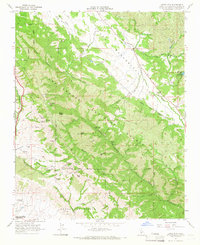 1965 Lopez Mountain1966 Print · USGSThe backcountry of San Luis Obispo County is captured here in the mid-sixties, showing the intersection of forest service management and early industrial exploration. Researchers can trace remote sites like the Sulphur Pots, the Upper Lopez Campground, and a lone Oil Well near the Salinas River.4 unique versions available
 - 1965 Map of Arroyo Grande NE, 1967 Print
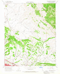 1965 Arroyo Grande NE1967 Print · USGSThe Central Coast hinterlands near Edna were a hub of rail activity and oil production in the mid-sixties. Genealogists and local historians can trace the foundations of the community through several local schools, the Southern Pacific corridor, and the Arroyo Grande Oil Field.6 unique versions available
 - 1965 Map of Pismo Beach, 1967 Print
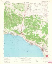 1965 Pismo Beach1967 Print · USGSThe Central Coast is documented during the mid-1960s as the seaside towns of the San Luis Obispo Bay began to expand. Genealogists and local historians can trace family-named sites like Squire Canyon and Gragg Canyon or locate early landmarks like Ontario Hot Springs and the Southern Pacific line.4 unique versions available
 - 1965 Map of San Luis Obispo, 1967 Print
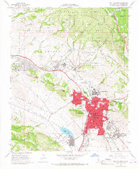 1965 San Luis Obispo1967 Print · USGSSan Luis Obispo and its surrounding hills are captured here in the mid-1960s, showing a growing college town and its vital rail and military links. Researchers can trace historic landmarks like the Old Mission, the rugged path to Cuesta Pass, and the sprawl of Cal Poly.5 unique versions available
End of results
Showing maps 1-4 of 4
Top cities near San Luis Obispo
- Atascadero historical maps
- Arroyo Grande historical maps
- Grover Beach historical maps
- Morro Bay historical maps
- Pismo Beach historical maps
- Oceano historical maps
See more
Top neighborhoods of San Luis Obispo
- Mill Street District historical maps
- Vinifera historical maps
- South Morros historical maps
- Downtown historical maps
- Japantown historical maps
- Little Italy historical maps
See more
Frequently asked questions
- What are the different types of historical maps available for San Luis Obispo?
- What is the oldest map of San Luis Obispo?
- Where can I purchase historical maps of San Luis Obispo for my home or office?
- Where can I download high-res historical maps of San Luis Obispo?
- Are there historical topographic maps available for San Luis Obispo?
- Is there historical aerial imagery available for San Luis Obispo?
- Where are historical maps of San Luis Obispo sourced from?