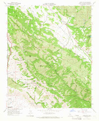
1965 Map of Lopez Mountain
USGS Topo · Published 1966About this map
Los Padres National Forest dominates this mid-1960s survey, revealing a landscape defined by sharp ridges and deep riparian canyons. The upper reaches of the Salinas River flow through the northeast corner, joined by tributaries like Las Pilitas Creek and Rinconada Creek. This era of the forest is marked by recreational and industrial pockets, including the Upper Lopez Campground and a specific Oil Well located near the riverbank. High peaks such as Mt Lowe and Lopez Mtn provide significant vertical relief above the winding Lopez Canyon. The presence of Sulphur Pots along the canyon floor suggests the unique geothermal or mineral character of the local geology. Numerous springs are mapped throughout the hills, indicating the critical water sources that supported early cattle ranching and homesteading on flats like Yerba Buena Flat.
Find a feature on this map
35 named features on this map. Tap any name to fly to it.
Don’t see what you’re looking for? This feature index may not catch every label — zoom into the map to look around manually.
Map Details
Editions of this 1965 Lopez Mountain Map
4 editions found
Other maps of this area

1897 · San Luis Obispo
USGS Topo · 1:62,500

1897 · Arroyo Grande
USGS Topo · 1:62,500

1900 · San Luis
USGS Topo · 1:125,000

1922 · Pozo
USGS Topo · 1:62,500

1922 · Nipomo
USGS Topo · 1:62,500

1942 · San Luis Obispo
USGS Topo · 1:62,500

1942 · Arroyo Grande
USGS Topo · 1:62,500

1947 · San Luis Obispo
USGS Topo · 1:250,000

1948 · San Luis Obispo
USGS Topo · 1:250,000

1952 · Arroyo Grande
USGS Topo · 1:62,500