1990s Maps of San Luis Obispo, California
Explore 4 historic maps of San Luis Obispo from the 1990s. These maps offer a rare glimpse into what life looked like during the 1990s — showing old roads, neighborhoods, homes, and landmarks that have changed or disappeared over time.
Whether you're researching your family's past, planning a metal detecting trip, or studying how San Luis Obispo's landscape evolved across the 1990s, these high-resolution maps are a powerful tool for exploring the history of this region.
- Focus on a specific era: All maps on this page are from the 1990s, giving you a focused view of this time period.
- See what’s changed: Compare century-old streets, trails, and buildings to today's modern landscape using overlays and satellite layers.
- Research with precision: Use these maps for genealogy, historical research, land use analysis, or educational projects.
- View, download, or print: Maps are fully viewable online in high resolution, and can be downloaded or printed for your own records.
Start exploring San Luis Obispo's history through authentic maps from the 1990s. This is your window into the past.
San Luis Obispo, CA maps
(4)- 1995 Map of San Luis Obispo, 2000 Print
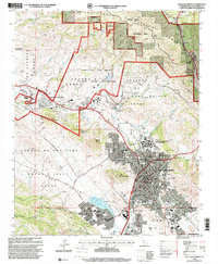 1995 San Luis Obispo2000 Print · USGSSan Luis Obispo and its surrounding volcanic peaks are captured in the mid-1990s as the city and university expand. Researchers can trace the legacy of the Southern Pacific RR through Cuesta Pass or locate ancestral sites like the Catholic Cem and Old Mission San Luis Obispo de Tolosa.
 - 1995 Map of Arroyo Grande NE, 2000 Print
 1995 Arroyo Grande NE2000 Print · USGSThe San Luis Obispo coastline and its inland canyons come into focus in the mid-1990s as suburban growth reaches the edge of historic land grants. Genealogists and local historians can trace school sites like Independence School and Brauch School, or the boundaries of the Santa Manuela Grant.
 - 1995 Map of Lopez Mountain, 2000 Print
 1995 Lopez Mountain2000 Print · USGSThe Santa Lucia Range in the mid-nineties shows a landscape of protected wilderness and historic land grants. Genealogists and hikers can trace remote locations like Upper Lopez Campsite, the Salinas River, and peaks like Gay Mountain.
 - 1998 Map of Pismo Beach, 2002 Print
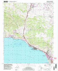 1998 Pismo Beach2002 Print · USGSThe Central California coast near the end of the century shows a unique balance of rugged canyons and expanding seaside towns. Researchers can trace the development of Pismo Beach and Avila Beach, or locate landmarks like the County Wharf and the Pismo Lake Ecological Reserve.
End of results
Showing maps 1-4 of 4
Top cities near San Luis Obispo
- Atascadero historical maps
- Arroyo Grande historical maps
- Grover Beach historical maps
- Morro Bay historical maps
- Pismo Beach historical maps
- Oceano historical maps
See more
Top neighborhoods of San Luis Obispo
- Mill Street District historical maps
- Vinifera historical maps
- South Morros historical maps
- Downtown historical maps
- Japantown historical maps
- Little Italy historical maps
See more
Frequently asked questions
- What are the different types of historical maps available for San Luis Obispo?
- What is the oldest map of San Luis Obispo?
- Where can I purchase historical maps of San Luis Obispo for my home or office?
- Where can I download high-res historical maps of San Luis Obispo?
- Are there historical topographic maps available for San Luis Obispo?
- Is there historical aerial imagery available for San Luis Obispo?
- Where are historical maps of San Luis Obispo sourced from?