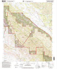
1995 Map of Lopez Mountain
USGS Topo · Published 2000About this map
Lopez Mountain stands as a prominent landmark in this mid-1990s survey of the Central Coast interior. The landscape is defined by the protected acreage of the Los Padres National Forest and the Santa Lucia Wilderness, where human activity is limited to remote outposts like Upper Lopez Campsite and Sulphur Pot Campsite. The survey captures a network of drainages including Trout Creek and Rinconada Creek feeding toward the Salinas River and the northern tip of Santa Margarita Lake.
Find a feature on this map
42 named features on this map. Tap any name to fly to it.
Don’t see what you’re looking for? This feature index may not catch every label — zoom into the map to look around manually.
Map Details
Editions of this 1995 Lopez Mountain Map
This is the sole edition of this map. No revisions or reprints were ever made.
Other maps of this area

1897 · San Luis Obispo
USGS Topo · 1:62,500

1897 · Arroyo Grande
USGS Topo · 1:62,500

1900 · San Luis
USGS Topo · 1:125,000

1922 · Pozo
USGS Topo · 1:62,500

1922 · Nipomo
USGS Topo · 1:62,500

1942 · San Luis Obispo
USGS Topo · 1:62,500

1942 · Arroyo Grande
USGS Topo · 1:62,500

1947 · San Luis Obispo
USGS Topo · 1:250,000

1948 · San Luis Obispo
USGS Topo · 1:250,000

1952 · Arroyo Grande
USGS Topo · 1:62,500