1990s Maps of Portola Valley, California
Explore 8 historic maps of Portola Valley from the 1990s. These maps offer a rare glimpse into what life looked like during the 1990s — showing old roads, neighborhoods, homes, and landmarks that have changed or disappeared over time.
Whether you're researching your family's past, planning a metal detecting trip, or studying how Portola Valley's landscape evolved across the 1990s, these high-resolution maps are a powerful tool for exploring the history of this region.
- Focus on a specific era: All maps on this page are from the 1990s, giving you a focused view of this time period.
- See what’s changed: Compare century-old streets, trails, and buildings to today's modern landscape using overlays and satellite layers.
- Research with precision: Use these maps for genealogy, historical research, land use analysis, or educational projects.
- View, download, or print: Maps are fully viewable online in high resolution, and can be downloaded or printed for your own records.
Start exploring Portola Valley's history through authentic maps from the 1990s. This is your window into the past.
Portola Valley, CA maps
(8)- 1991 Map of Woodside, 1995 Print
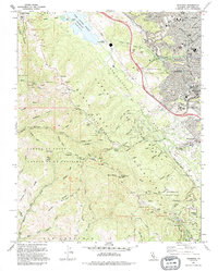 1991 Woodside1995 Print · USGSThe Peninsula mountains and the San Andreas Rift Zone are captured here in the early nineties as residential growth met preserved ridge lands. Researchers can locate family landmarks like Adobe Corner, local schools such as Heather Sch, and the unique Pulgas Water Temple.
 - 1991 Map of Palo Alto, 1995 Print
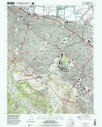
 1991 Palo Alto1995 Print · USGSThe Peninsula's transition from bayfront industry to academic sprawling is captured here in the early nineties. Genealogists and researchers can trace local institutions like St Patrick Seminary, Holy Cross Cem, and the massive Stanford University campus.2 unique versions available
 - 1991 Map of La Honda, 1995 Print
 1991 La Honda1995 Print · USGSThe Santa Cruz Mountains in the early nineties show a landscape of redwood-canopy retreats and institutional ranches. Genealogists and local historians can trace the footprints of Redwood Terrace, Pomponio Ranch, and the Oil Wells near Kingston Cr.
 - 1991 Map of Mindego Hill, 1995 Print
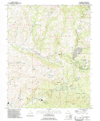
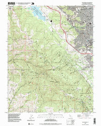
 1991 Mindego Hill1995 Print · USGSThe foothills of the Santa Cruz Mountains come alive in this early nineties survey of the San Mateo and Santa Clara borderlands. Genealogists and hikers can trace the boundaries of Portola State Park, the San Francisco Log Cabin Ranch, and family landmarks like Ewing Hill.2 unique versions available
 - 1997 Map of La Honda, 1999 Print
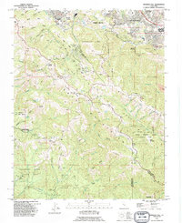
 1997 La Honda1999 Print · USGSCoastal San Mateo County's ridge-and-valley landscape appears here in the late twentieth century, showing a region of dense woods and scattered rural enclaves. Researchers can trace the layout of family-named ranches and youth camps like Pomponio Ranch and San Francisco Camp.
 - 1997 Map of Woodside, 1999 Print
 1997 Woodside1999 Print · USGSThe San Mateo highlands were a mosaic of suburban growth and preserved mountain terrain in the late nineties. Explore the historic Old Woodside Store, trace the San Andreas Rift Zone, and locate schools like Kings Mtn Sch and St Pius Sch.
 - 1997 Map of Palo Alto, 1999 Print
 1997 Palo Alto1999 Print · USGSSilicon Valley's academic and industrial heart is captured here in the late nineties as suburbs reached the Santa Cruz foothills. Researchers can trace the sprawling grounds of Stanford University Medical Center, the Linear Accelerator, and local landmarks like Alta Mesa Cem.
 - 1997 Map of Mindego Hill, 1999 Print
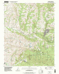
 1997 Mindego Hill1999 Print · USGSThe peninsula ridgeline south of Portola Valley is shown here in the late twentieth century as a landscape of protected parks and high-elevation enclaves. Researchers can trace the boundaries of Coal Mine Ridge, locate the San Francisco Log Cabin Ranch, and find family-named landmarks like Borel Hill.
End of results
Showing maps 1-8 of 8
Top cities near Portola Valley
- San Jose historical maps
- Fremont historical maps
- Hayward historical maps
- Sunnyvale historical maps
- Santa Clara historical maps
- San Mateo historical maps
See more
Top neighborhoods of Portola Valley
Frequently asked questions
- What are the different types of historical maps available for Portola Valley?
- What is the oldest map of Portola Valley?
- Where can I purchase historical maps of Portola Valley for my home or office?
- Where can I download high-res historical maps of Portola Valley?
- Are there historical topographic maps available for Portola Valley?
- Is there historical aerial imagery available for Portola Valley?
- Where are historical maps of Portola Valley sourced from?