Old Maps of Cachuma Village, California
Explore 18 old maps of Cachuma Village, spanning from 1902 to today. These high-resolution historic maps reveal how streets, neighborhoods, landmarks, and natural features evolved over time — perfect for genealogy, metal detecting, research, and local history exploration.
What you can do with these maps:
- See how Cachuma Village changed over time: Compare historical maps to modern-day views to trace roads, homesites, rail lines & more.
- View detailed metadata: Each map includes creators, publishers, year, scale, and archive source.
- Overlay maps with satellite & LiDAR: Visualize the past alongside modern tools to explore terrain & human change.
- Trusted historical sources: Maps sourced from the USGS, Library of Congress, and other archives.
- Access maps your way: View online, download high-res files, or order prints for personal or research use.
Start exploring old maps of Cachuma Village to uncover forgotten places, hidden landmarks, and the deep history beneath your feet.
Cachuma Village, CA maps
(18)- 1902 Map of Santa Ynez
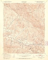
 1902 Santa Ynez1902 Print · USGSSanta Barbara County at the turn of the century was a land of high mountain meadows and isolated ranching outposts. Genealogists can trace family holdings at Cuyama Ranch or follow old trails through Salisbury Potrero and the San Rafael Mountains.
 - 1905 Map of Santa Ynez
 1905 Santa Ynez1905 Print · USGSThe Santa Barbara backcountry is shown here at the start of the twentieth century, focusing on the high ridges and canyons of the San Rafael Mountains. Genealogists and hikers can trace early routes through San Marcos Pass or locate old sites like Wasioja and the Montgomery Potrero.5 unique versions available
 - 1941 Map of San Rafael Mtn. , 1955 Print
 1941 San Rafael Mtn.1955 Print · USGSSanta Barbara County’s backcountry comes into focus during the early 1940s, showing a rugged landscape of high peaks and river-valley ranches. Researchers can locate remote sites like the Redrock Quicksilver Mine and Rancho San Fernando Rey or trace the route to Cold Spring Tavern.3 unique versions available
 - 1942 Map of San Rafael Mtn. , 1945 Print
 1942 San Rafael Mtn.1945 Print · USGSThe Santa Barbara backcountry in the early 1940s is shown here as a network of canyon ranches and mountain fire lookouts. Genealogists and historians can trace family properties like Storke Ranch or locate the Redrock Quicksilver Mine and Cold Spring Tavern.
 - 1943 Map of San Rafael Mtn.
 1943 San Rafael Mtn.1943 Print · USGSSanta Barbara's interior mountains during the Second World War reveal a landscape of remote quicksilver mining and sprawling cattle ranches. Researchers can trace historic properties like Rancho San Fernando Rey and landmarks like Cold Spring Tavern or the Redrock Quicksilver Mine.
 - 1949 Map of Los Angeles
 1949 Los Angeles1949 Print · USGSSouthern California and the South Coast appear at the onset of the post-war boom, from the Channel Islands to the Mojave Desert. Trace early aviation sites like Lockheed Air Terminal and mining history at the Redrock Quicksilver Mine and Redrover Mine.2 unique versions available
 - 1955 Map of Los Angeles
 1955 Los Angeles1955 Print · USGSThe mid-century transformation of Southern California comes into focus as the urban sprawl of Los Angeles meets the wilderness of the Santa Monica Mountains. Researchers can trace the development of post-war suburbs alongside historic landmarks like the Santa Barbara Lighthouse and early industrial sites such as the Good Luck Mine.
 - 1959 Map of Los Angeles
 1959 Los Angeles1959 Print · USGSCoastal California and the high desert met in a period of booming growth after the war. Researchers can trace early aviation and military history at the Point Mugu Air Missile Test Ctr or locate desert mining sites like the Double Eagle Mine.3 unique versions available
 - 1959 Map of Lake Cachuma, 1960 Print
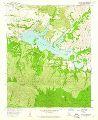 1959 Lake Cachuma1960 Print · USGSSanta Barbara County’s backcountry underwent a massive transformation in the late fifties as the reservoir filled behind the new dam. Genealogists and historians can locate Cachuma Village, the sprawling Rancho San Fernando Rey, and remote fire lookouts like Santa Ynez Peak.4 unique versions available
 - 1959 Map of San Rafael Mtn, 1963 Print
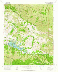 1959 San Rafael Mtn1963 Print · USGSThe San Rafael Mountains are captured here just after the filling of the reservoir, as recreation and forestry infrastructure expanded in the late fifties. Trace the layout of Cachuma Village, locate the remote Peacock Mine, or find the site of San Marcos Sch.2 unique versions available
 - 1966 Map of Los Angeles
 1966 Los Angeles1966 Print · USGSSouthern California underwent a mid-century transformation as suburban grids reached the base of the San Gabriel Mountains. Researchers can trace the path of the Los Angeles Aqueduct or locate defense landmarks like Edwards Air Force Base.
 - 1975 Map of Los Angeles, 1977 Print
 1975 Los Angeles1977 Print · USGSSouthern California is captured in a period of significant growth during the mid-seventies, showing the urban sprawl from the coast to the high desert. Researchers can trace the development of the Pacific Coast Hwy and find aerospace landmarks like Edwards Air Force Base and the Flight Test Center (NASA).2 unique versions available
 - 1981 Map of Cuyama
 1981 Cuyama1981 Print · USGSThe high Cuyama Valley and the vast reaches of the Los Padres National Forest are captured here in the early eighties. Researchers can trace the San Andreas Rift Zone past New Cuyama or locate remote outposts like the Gibraltar Mine and Thorn Lookout.2 unique versions available
 - 1995 Map of Lake Cachuma, 2000 Print
 1995 Lake Cachuma2000 Print · USGSSanta Barbara County near the Santa Ynez River was well-established as a recreation and conservation hub by the mid-1990s. Trace the landscape from the Bradbury Dam to the Rancho Alegre Boy Scout Camp and the Bee Rock Quarry.
 - 2012 Map of Lake Cachuma, 2012 Print
 2012 Lake Cachuma2012 Print · USGSCovers Cachuma Village, including Santa Barbara County, United States, and other nearby areas
 - 2015 Map of Lake Cachuma, 2015 Print
 2015 Lake Cachuma2015 Print · USGSCovers Cachuma Village, including Santa Barbara County, United States, and other nearby areas
 - 2018 Map of Lake Cachuma, 2018 Print
 2018 Lake Cachuma2018 Print · USGSCovers Cachuma Village, including Santa Barbara County, United States, and other nearby areas
 - 2021 Map of Lake Cachuma, 2021 Print
 2021 Lake Cachuma2021 Print · USGSSanta Barbara County's coastal mountains and reservoir are detailed here in the 2020s. Researchers can trace the shoreline of Lake Cachuma and locate landmarks from Cachuma Village to the heights of Broadcast Peak.
End of results
Showing maps 1-18 of 18
Top cities near Cachuma Village
- Santa Barbara historical maps
- Goleta historical maps
- Isla Vista historical maps
- Solvang historical maps
- Santa Ynez historical maps
- Buellton historical maps
See more
Frequently asked questions
- What are the different types of historical maps available for Cachuma Village?
- What is the oldest map of Cachuma Village?
- Where can I purchase historical maps of Cachuma Village for my home or office?
- Where can I download high-res historical maps of Cachuma Village?
- Are there historical topographic maps available for Cachuma Village?
- Is there historical aerial imagery available for Cachuma Village?
- Where are historical maps of Cachuma Village sourced from?