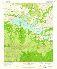
1959 Map of Lake Cachuma
USGS Topo · Published 1960About this map
Lake Cachuma dominates the central landscape of this 1959 survey, held by the recently completed Cachuma Dam which transformed the Santa Ynez River valley. The reservoir's reach is defined by complex inlets like Cachuma Bay and Santa Cruz Bay, surrounded by the extensive Cachuma Recreation Area. This era of water management and public leisure is anchored by Cachuma Village and the Cachuma County Park.
Find a feature on this map
56 named features on this map. Tap any name to fly to it.
Don’t see what you’re looking for? This feature index may not catch every label — zoom into the map to look around manually.
Map Details
Editions of this 1959 Lake Cachuma Map
4 editions found
Other maps of this area

1902 · Santa Ynez
USGS Topo · 1:125,000

1905 · Santa Ynez
USGS Topo · 1:125,000

1905 · Lompoc
USGS Topo · 1:125,000

1941 · San Rafael Mtn.
USGS Topo · 1:62,500

1942 · Lompoc
USGS Topo · 1:125,000

1942 · Gaviota
USGS Topo · 1:62,500

1942 · Goleta
USGS Topo · 1:62,500

1942 · San Rafael Mtn.
USGS Topo · 1:62,500

1942 · Los Olivos
USGS Topo · 1:62,500

1943 · San Rafael Mtn.
USGS Topo · 1:62,500