1950s Maps of Carpinteria, California
Explore 6 historic maps of Carpinteria from the 1950s. These maps offer a rare glimpse into what life looked like during the 1950s — showing old roads, neighborhoods, homes, and landmarks that have changed or disappeared over time.
Whether you're researching your family's past, planning a metal detecting trip, or studying how Carpinteria's landscape evolved across the 1950s, these high-resolution maps are a powerful tool for exploring the history of this region.
- Focus on a specific era: All maps on this page are from the 1950s, giving you a focused view of this time period.
- See what’s changed: Compare century-old streets, trails, and buildings to today's modern landscape using overlays and satellite layers.
- Research with precision: Use these maps for genealogy, historical research, land use analysis, or educational projects.
- View, download, or print: Maps are fully viewable online in high resolution, and can be downloaded or printed for your own records.
Start exploring Carpinteria's history through authentic maps from the 1950s. This is your window into the past.
Carpinteria, CA maps
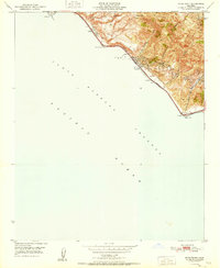
(6)- 1950 Map of Pitas Point, 1955 Print
 1950 Pitas Point1955 Print · USGSCoastal Ventura County comes into focus in the early fifties, showing the narrow passage between the steep hills and the Pacific Ocean. Researchers can trace the railroad line past Punta and locate water sources like Los Sauces Creek and Rincon Cr.3 unique versions available
 - 1951 Map of Pitas Point
 1951 Pitas Point1951 Print · USGSThe Ventura coast in the early fifties shows a busy corridor of petroleum production and transit squeezed between the mountains and the sea. You can trace the Southern Pacific tracks and Highway 101 past the settlement of Sea Cliff and numerous Oil Wells.2 unique versions available
 - 1952 Map of Carpinteria, 1953 Print
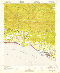 1952 Carpinteria1953 Print · USGSThe Santa Barbara coast during the early fifties shows a burgeoning network of seaside towns and mountain routes. Genealogists can trace family landmarks like Carpinteria Cemetery, Aliso Sch, and the residential growth near Sandyland Cove.8 unique versions available
 - 1952 Map of White Ledge Peak, 1953 Print
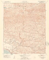 1952 White Ledge Peak1953 Print · USGSThe Santa Barbara coast and its inland mountains are captured here in the early fifties, showing the interplay of ranching and early aviation. Genealogists can trace family landmarks like Botello Ranch, locate the Cate School, or study the remote Billiard Flats.6 unique versions available
 - 1955 Map of Los Angeles
 1955 Los Angeles1955 Print · USGSThe mid-century transformation of Southern California comes into focus as the urban sprawl of Los Angeles meets the wilderness of the Santa Monica Mountains. Researchers can trace the development of post-war suburbs alongside historic landmarks like the Santa Barbara Lighthouse and early industrial sites such as the Good Luck Mine.
 - 1959 Map of Los Angeles
 1959 Los Angeles1959 Print · USGSCoastal California and the high desert met in a period of booming growth after the war. Researchers can trace early aviation and military history at the Point Mugu Air Missile Test Ctr or locate desert mining sites like the Double Eagle Mine.3 unique versions available
End of results
Showing maps 1-6 of 6
Top cities near Carpinteria
- Oxnard historical maps
- Ventura historical maps
- Santa Barbara historical maps
- Montecito historical maps
- Mission Canyon historical maps
- Toro Canyon historical maps
See more
Top neighborhoods of Carpinteria
Frequently asked questions
- What are the different types of historical maps available for Carpinteria?
- What is the oldest map of Carpinteria?
- Where can I purchase historical maps of Carpinteria for my home or office?
- Where can I download high-res historical maps of Carpinteria?
- Are there historical topographic maps available for Carpinteria?
- Is there historical aerial imagery available for Carpinteria?
- Where are historical maps of Carpinteria sourced from?