1990s Maps of Carpinteria, California
Explore 2 historic maps of Carpinteria from the 1990s. These maps offer a rare glimpse into what life looked like during the 1990s — showing old roads, neighborhoods, homes, and landmarks that have changed or disappeared over time.
Whether you're researching your family's past, planning a metal detecting trip, or studying how Carpinteria's landscape evolved across the 1990s, these high-resolution maps are a powerful tool for exploring the history of this region.
- Focus on a specific era: All maps on this page are from the 1990s, giving you a focused view of this time period.
- See what’s changed: Compare century-old streets, trails, and buildings to today's modern landscape using overlays and satellite layers.
- Research with precision: Use these maps for genealogy, historical research, land use analysis, or educational projects.
- View, download, or print: Maps are fully viewable online in high resolution, and can be downloaded or printed for your own records.
Start exploring Carpinteria's history through authentic maps from the 1990s. This is your window into the past.
Carpinteria, CA maps
(2)- 1995 Map of Carpinteria, 2000 Print
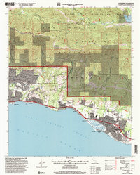 1995 Carpinteria2000 Print · USGSThe Santa Barbara coast and its rugged mountain backdrop are captured here in the mid-1990s as the region's agricultural and suburban identities merged. Genealogists and historians can trace families across the Carpinteria Cemetery or locate historic transit points like Old Town and the Southern Pacific line.
 - 1995 Map of White Ledge Peak, 2000 Print
 1995 White Ledge Peak2000 Print · USGSVentura and Santa Barbara Counties meet in the mid-nineties along a rugged coastline where the national forest meets the sea. Researchers can trace the layout of the Cate School, find the Rincon Station, and locate backcountry landmarks like Jameson Lake and Bonito Ranch.
End of results
Showing maps 1-2 of 2
Top cities near Carpinteria
- Oxnard historical maps
- Ventura historical maps
- Santa Barbara historical maps
- Montecito historical maps
- Mission Canyon historical maps
- Toro Canyon historical maps
See more
Top neighborhoods of Carpinteria
Frequently asked questions
- What are the different types of historical maps available for Carpinteria?
- What is the oldest map of Carpinteria?
- Where can I purchase historical maps of Carpinteria for my home or office?
- Where can I download high-res historical maps of Carpinteria?
- Are there historical topographic maps available for Carpinteria?
- Is there historical aerial imagery available for Carpinteria?
- Where are historical maps of Carpinteria sourced from?