Old Maps of Ventucopa, California for Metal Detecting
Plan your next treasure hunt with 16 historic maps of Ventucopa. Find old homesites, ghost towns, trails, and gathering spots that may be lost to time — perfect for identifying promising metal detecting locations.
- Locate forgotten sites: Uncover places like long-lost settlements, abandoned rail lines, or gathering spots.
- Plan better hunts: Use map overlays combined with LiDAR or satellite views to narrow in on historically rich areas.
- Made for detectorists: Thousands of hobbyists use these maps to discover relics, coins, and hidden history.
Use these historic maps to boost your research and find new opportunities beneath the surface of Ventucopa.
Ventucopa, CA maps
(16)- 1903 Map of Mt. Pinos
 1903 Mt. Pinos1903 Print · USGSVentura and Kern counties at the start of the century remain largely a wild backcountry of forest reserves and high peaks. Genealogists and historians can trace early outposts like Pattiway, the high-altitude Frazier Borax Mine, and the Pine Mtn Lodge.7 unique versions available
 - 1943 Map of Cuyama Peak, 1959 Print
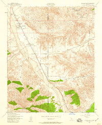 1943 Cuyama Peak1959 Print · USGSThe high desert ranchlands of the Cuyama Valley come to life in the early 1940s, showing a landscape defined by seasonal riverbeds and remote outposts. Researchers can trace historic family holdings like the Monreal Ranch and Stutz Ranch near the settlement of Ventucopa.5 unique versions available
 - 1944 Map of Cuyama Peak
 1944 Cuyama Peak1944 Print · USGSThe northern reaches of the Los Padres National Forest and the Cuyama Valley are shown in the mid-1940s as a thriving ranching corridor. Trace family holdings like Stutz Ranch and Kloppenberg or industrial sites like the Monolith Cement Co.
 - 1949 Map of Los Angeles
 1949 Los Angeles1949 Print · USGSSouthern California and the South Coast appear at the onset of the post-war boom, from the Channel Islands to the Mojave Desert. Trace early aviation sites like Lockheed Air Terminal and mining history at the Redrock Quicksilver Mine and Redrover Mine.2 unique versions available
 - 1955 Map of Los Angeles
 1955 Los Angeles1955 Print · USGSThe mid-century transformation of Southern California comes into focus as the urban sprawl of Los Angeles meets the wilderness of the Santa Monica Mountains. Researchers can trace the development of post-war suburbs alongside historic landmarks like the Santa Barbara Lighthouse and early industrial sites such as the Good Luck Mine.
 - 1959 Map of Los Angeles
 1959 Los Angeles1959 Print · USGSCoastal California and the high desert met in a period of booming growth after the war. Researchers can trace early aviation and military history at the Point Mugu Air Missile Test Ctr or locate desert mining sites like the Double Eagle Mine.3 unique versions available
 - 1966 Map of Los Angeles
 1966 Los Angeles1966 Print · USGSSouthern California underwent a mid-century transformation as suburban grids reached the base of the San Gabriel Mountains. Researchers can trace the path of the Los Angeles Aqueduct or locate defense landmarks like Edwards Air Force Base.
 - 1975 Map of Los Angeles, 1977 Print
 1975 Los Angeles1977 Print · USGSSouthern California is captured in a period of significant growth during the mid-seventies, showing the urban sprawl from the coast to the high desert. Researchers can trace the development of the Pacific Coast Hwy and find aerospace landmarks like Edwards Air Force Base and the Flight Test Center (NASA).2 unique versions available
 - 1977 Map of Cuyama Peak
 1977 Cuyama Peak1977 Print · USGSCovers Ventucopa, including Ventura County, Santa Barbara County, and other nearby areas
 - 1981 Map of Cuyama
 1981 Cuyama1981 Print · USGSThe high Cuyama Valley and the vast reaches of the Los Padres National Forest are captured here in the early eighties. Researchers can trace the San Andreas Rift Zone past New Cuyama or locate remote outposts like the Gibraltar Mine and Thorn Lookout.2 unique versions available
 - 1991 Map of Cuyama Peak
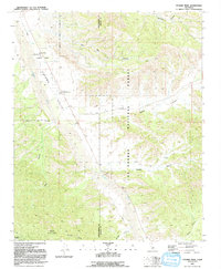 1991 Cuyama Peak1991 Print · USGSVentucopa and the upper Cuyama Valley are documented in the early nineties, showing a landscape defined by sharp canyons and forest service outposts. Researchers can trace land use through the Cuyama Peak Lookout, the small settlement of Burges, and the winding Cuyama River.2 unique versions available
 - 1995 Map of Cuyama Peak, 2000 Print
 1995 Cuyama Peak2000 Print · USGSVentucopa and the upper reaches of the Cuyama Valley are captured in the mid-1990s as the local economy balanced ranching with forest management. Researchers can trace the path of the Cuyama River and find landmarks like the Ventucopa Work Center, Apache Canyon, and Cuyama Lookout Peak.
 - 2012 Map of Cuyama Peak, 2012 Print
 2012 Cuyama Peak2012 Print · USGSCovers Ventucopa, including Ventura County, Santa Barbara County, and other nearby areas
 - 2015 Map of Cuyama Peak, 2015 Print
 2015 Cuyama Peak2015 Print · USGSCovers Ventucopa, including Ventura County, Santa Barbara County, and other nearby areas
 - 2018 Map of Cuyama Peak, 2018 Print
 2018 Cuyama Peak2018 Print · USGSCovers Ventucopa, including Ventura County, Santa Barbara County, and other nearby areas
 - 2021 Map of Cuyama Peak, 2021 Print
 2021 Cuyama Peak2021 Print · USGSVentucopa and the Cuyama Valley are captured in this recent survey, showcasing the remote highlands of Ventura County. Geologists and local explorers can trace the extensive trail networks through Ballinger Canyon, Quatal Canyon, and up to the summit of Cuyama Peak.
End of results
Showing maps 1-16 of 16
Top cities near Ventucopa
Frequently asked questions
- What are the different types of historical maps available for Ventucopa?
- What is the oldest map of Ventucopa?
- Where can I purchase historical maps of Ventucopa for my home or office?
- Where can I download high-res historical maps of Ventucopa?
- Are there historical topographic maps available for Ventucopa?
- Is there historical aerial imagery available for Ventucopa?
- Where are historical maps of Ventucopa sourced from?