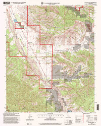
1995 Map of Cuyama Peak
USGS Topo · Published 2000About this map
The Cuyama Valley serves as a primary corridor through this high-desert landscape, anchored by the small settlement of Ventucopa. This 1990s revision by the Forest Service highlights a rugged transition between agricultural use and protected land, with the Cuyama River winding southward past a Gravel Pit and scattered infrastructure like the Ventucopa Work Center. Steep drainages such as Quatal Canyon, Brubaker Canyon, and Apache Canyon carve into the mountain slopes, illustrating the complex hydrology of the Los Padres National Forest. To the southwest, the terrain rises sharply toward the Dick Smith Wilderness, where the summit of Cuyama Lookout Peak provides a dominant vantage point over the county line dividing Santa Barbara and Ventura Counties. The placement of wells and water tanks throughout the valley underscores the critical role of water management for the community in this arid climate.
Find a feature on this map
19 named features on this map. Tap any name to fly to it.
Don’t see what you’re looking for? This feature index may not catch every label — zoom into the map to look around manually.
Map Details
Editions of this 1995 Cuyama Peak Map
This is the sole edition of this map. No revisions or reprints were ever made.
Other maps of this area

1902 · Santa Ynez
USGS Topo · 1:125,000

1903 · Mt. Pinos
USGS Topo · 1:125,000

1905 · Santa Ynez
USGS Topo · 1:125,000

1942 · Ballinger Canyon
USGS Topo · 1:24,000

1942 · East of Cuyama Ranch
USGS Topo · 1:24,000

1943 · Rancho Nuevo Creek
USGS Topo · 1:24,000

1943 · Apache Canyon
USGS Topo · 1:24,000

1943 · Santiago Creek
USGS Topo · 1:24,000
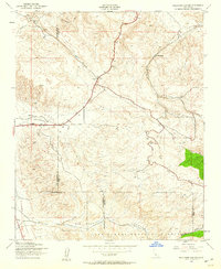
1943 · Ballinger Canyon
USGS Topo · 1:24,000

1943 · Cuyama Peak
USGS Topo · 1:24,000