1990s Maps of Davenport, California
Explore 2 historic maps of Davenport from the 1990s. These maps offer a rare glimpse into what life looked like during the 1990s — showing old roads, neighborhoods, homes, and landmarks that have changed or disappeared over time.
Whether you're researching your family's past, planning a metal detecting trip, or studying how Davenport's landscape evolved across the 1990s, these high-resolution maps are a powerful tool for exploring the history of this region.
- Focus on a specific era: All maps on this page are from the 1990s, giving you a focused view of this time period.
- See what’s changed: Compare century-old streets, trails, and buildings to today's modern landscape using overlays and satellite layers.
- Research with precision: Use these maps for genealogy, historical research, land use analysis, or educational projects.
- View, download, or print: Maps are fully viewable online in high resolution, and can be downloaded or printed for your own records.
Start exploring Davenport's history through authentic maps from the 1990s. This is your window into the past.
Davenport, CA maps
(2)- 1991 Map of Davenport, 1995 Print
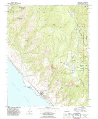 1991 Davenport1995 Print · USGSCoastal Santa Cruz County comes into focus during the early nineties, showing a landscape defined by redwood forests and industrial heritage. Trace the infrastructure of the Cement Plant at Davenport or explore the winding mountain roads near Bonny Doon and Swanton.
 - 1997 Map of Davenport, 1999 Print
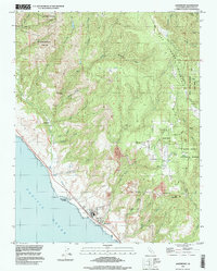 1997 Davenport1999 Print · USGSThe Santa Cruz coast and redwood highlands are captured here in the late nineties, featuring the industrial hub at Davenport. Researchers can trace the inland ridge settlements of Bonny Doon and the historical site of the Big Creek Powerhouse.
End of results
Showing maps 1-2 of 2
Top cities near Davenport
- San Jose historical maps
- Santa Cruz historical maps
- Los Gatos historical maps
- Scotts Valley historical maps
- Capitola historical maps
- Live Oak historical maps
See more
Frequently asked questions
- What are the different types of historical maps available for Davenport?
- What is the oldest map of Davenport?
- Where can I purchase historical maps of Davenport for my home or office?
- Where can I download high-res historical maps of Davenport?
- Are there historical topographic maps available for Davenport?
- Is there historical aerial imagery available for Davenport?
- Where are historical maps of Davenport sourced from?