1990s Maps of Spalding Corner, California
Explore 2 historic maps of Spalding Corner from the 1990s. These maps offer a rare glimpse into what life looked like during the 1990s — showing old roads, neighborhoods, homes, and landmarks that have changed or disappeared over time.
Whether you're researching your family's past, planning a metal detecting trip, or studying how Spalding Corner's landscape evolved across the 1990s, these high-resolution maps are a powerful tool for exploring the history of this region.
- Focus on a specific era: All maps on this page are from the 1990s, giving you a focused view of this time period.
- See what’s changed: Compare century-old streets, trails, and buildings to today's modern landscape using overlays and satellite layers.
- Research with precision: Use these maps for genealogy, historical research, land use analysis, or educational projects.
- View, download, or print: Maps are fully viewable online in high resolution, and can be downloaded or printed for your own records.
Start exploring Spalding Corner's history through authentic maps from the 1990s. This is your window into the past.
Spalding Corner, CA maps
(2)- 1990 Map of East of Pondosa
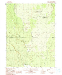 1990 East of Pondosa1990 Print · USGSThe timberlands of Northern California appear in the 1990s as a landscape defined by volcanic geology and forest management. Researchers can trace remote junctions like Hammond Crossing and Spalding Corner near the banks of Bear Creek.
 - 1995 Map of East of Pondosa, 1997 Print
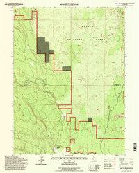 1995 East of Pondosa1997 Print · USGSThe Siskiyou and Shasta county line passes through this timbered wilderness in the mid-1990s as it gives way to volcanic flats. Trace the remote junctions of Hammond Crossing and Spalding Corner or follow the path of Bear Creek past rugged lava flows.
End of results
Showing maps 1-2 of 2
Frequently asked questions
- What are the different types of historical maps available for Spalding Corner?
- What is the oldest map of Spalding Corner?
- Where can I purchase historical maps of Spalding Corner for my home or office?
- Where can I download high-res historical maps of Spalding Corner?
- Are there historical topographic maps available for Spalding Corner?
- Is there historical aerial imagery available for Spalding Corner?
- Where are historical maps of Spalding Corner sourced from?